On The Go Tours
Our agents are waiting to chat to you...
Are you a Travel Agent or Customer?
Do you have an booking reference?
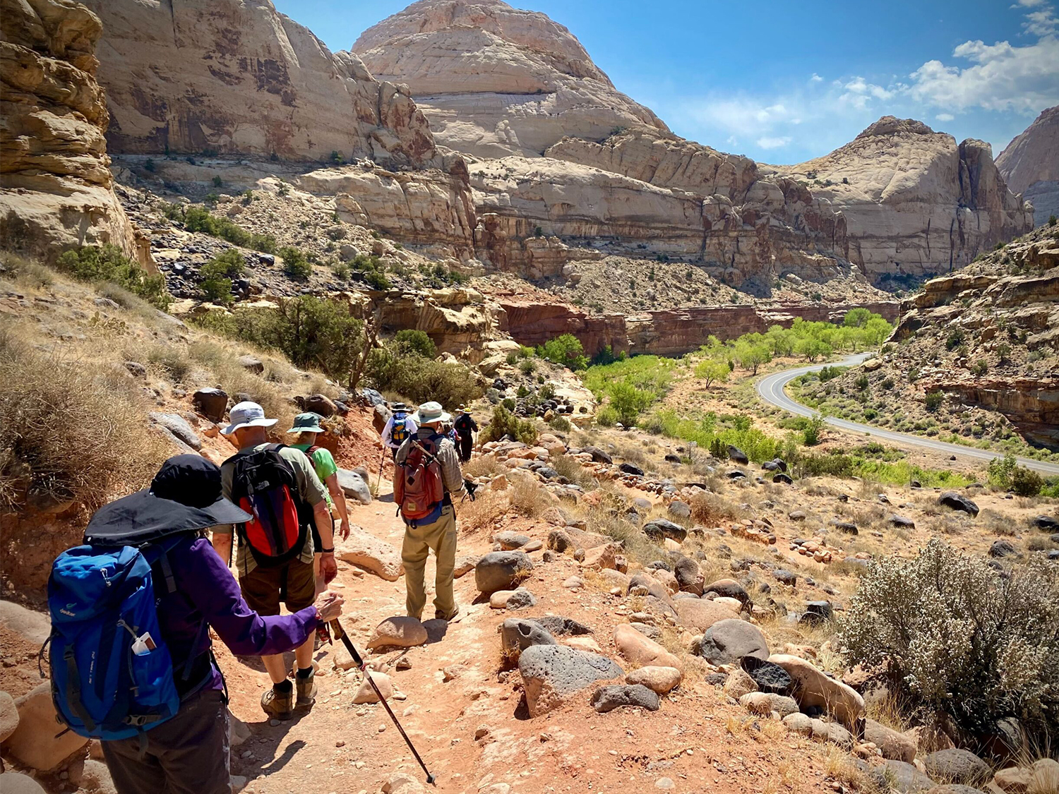
Top 10 Must-Visit USA National ParksThe Ultimate List of Must-See National Parks in the USA
When do you want to go?
2026
I'm flexible
Passengers
Adults (18+)
Children (0 - 17)
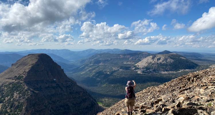
Exploring the Wonders of the USA’s National Parks
The United States boasts an incredible array of national parks, each offering a unique glimpse into the natural beauty, history, and geology of the country. Among the 63 designated national parks, a few stand out for their iconic landscapes and breath-taking experiences.
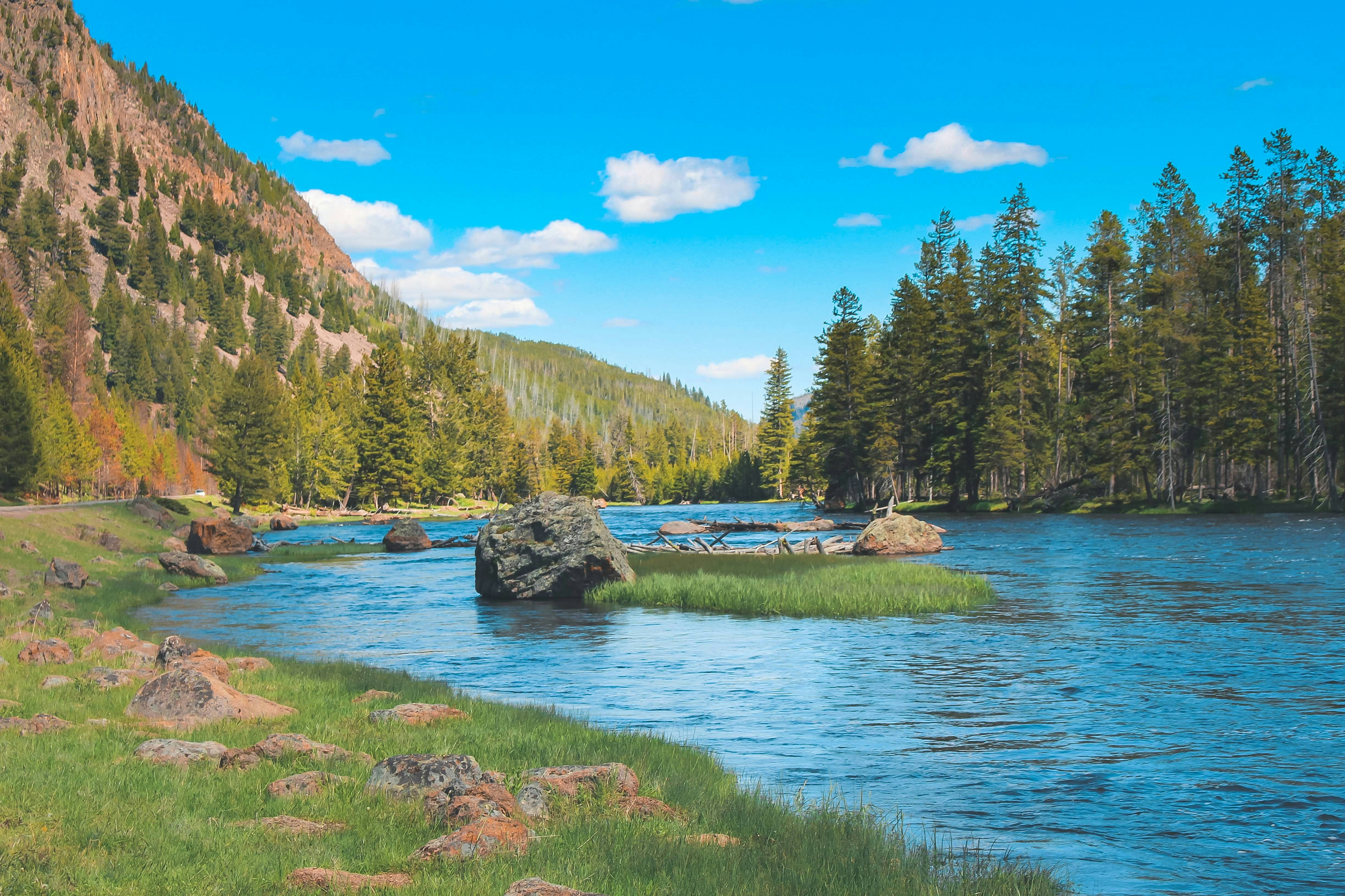
Yellowstone National Park
States: Wyoming, Montana and Idaho
Yellowstone National Park, located primarily in Wyoming, with portions of the park extending into Montana and Idaho, is the first national park in the United States. The park was established in 1872. It spans over 2.2 million acres and is renowned for its geothermal features, diverse ecosystems, and breathtaking landscapes.
Our guided tours to Yellowstone
Yellowstone & Yosemite (Camping/Hotel)
More about Yellowstone National Park
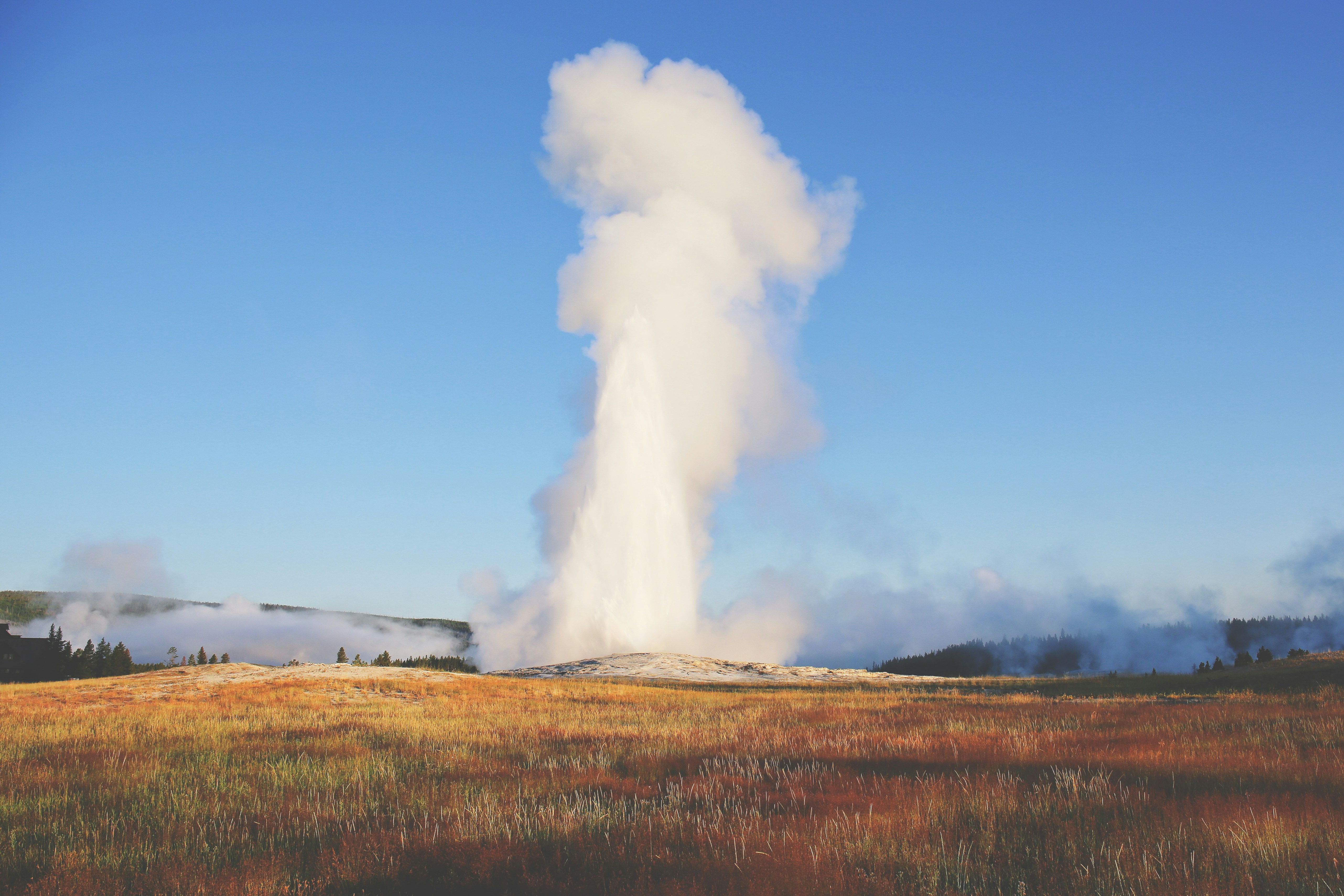
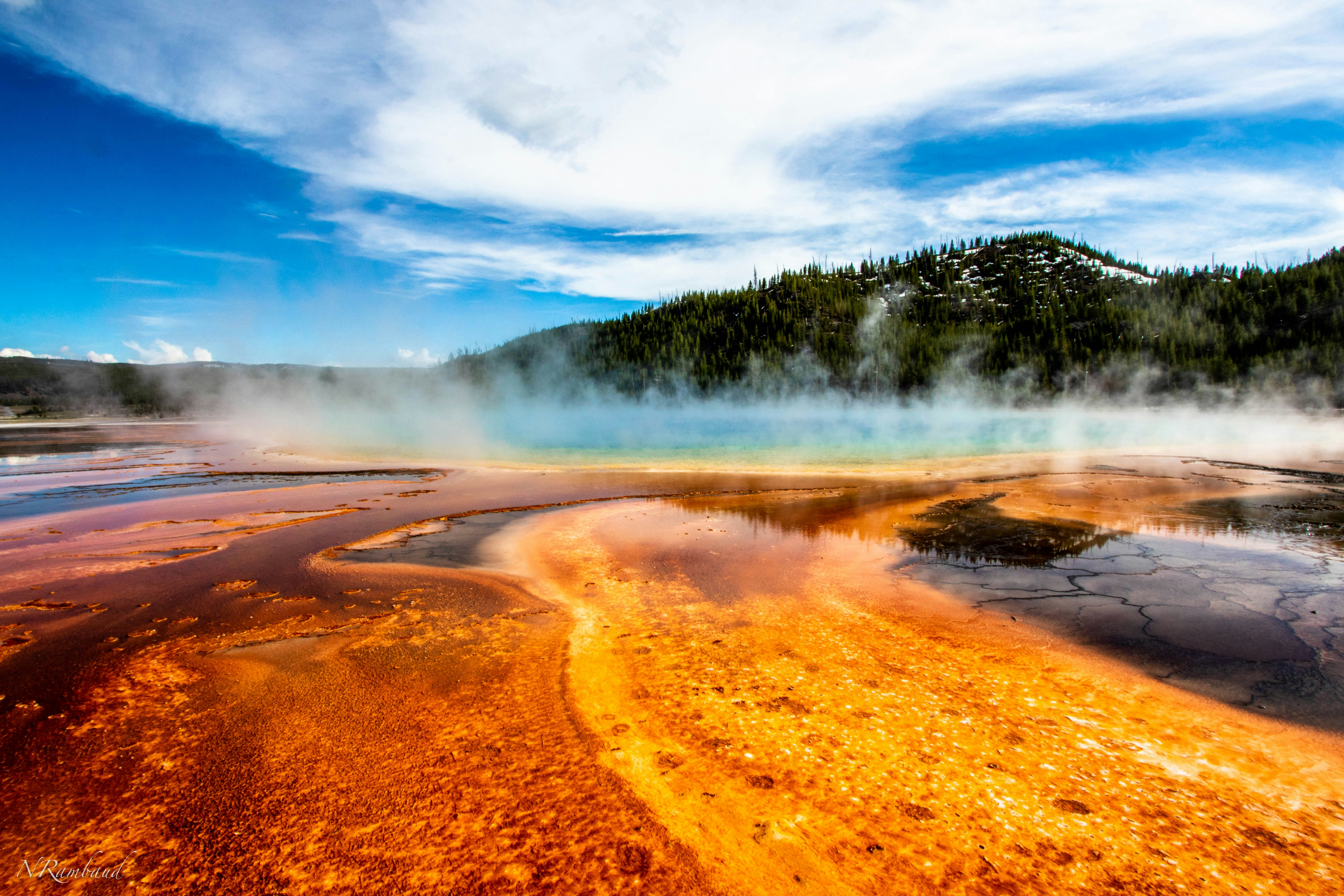
Geothermal Features
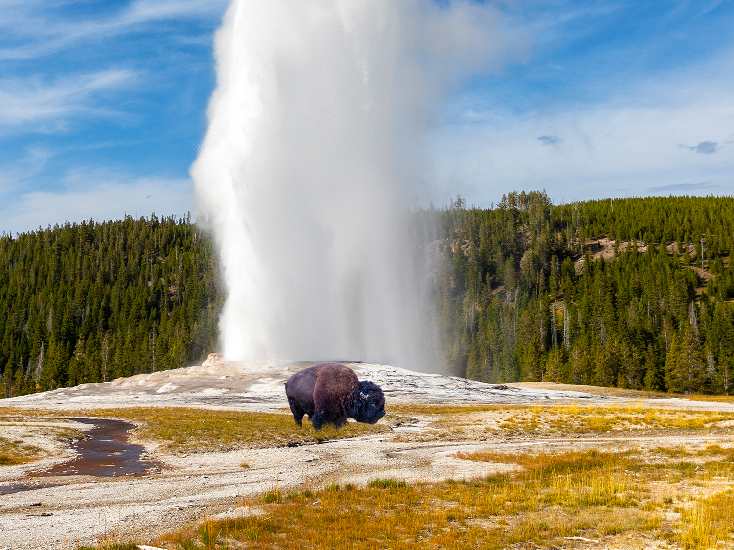
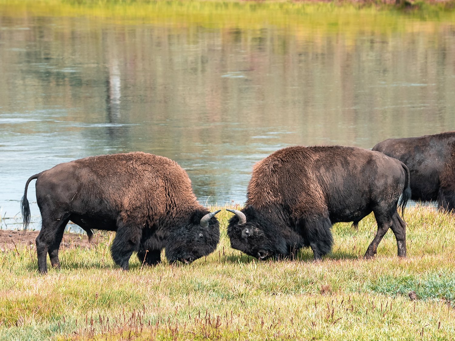
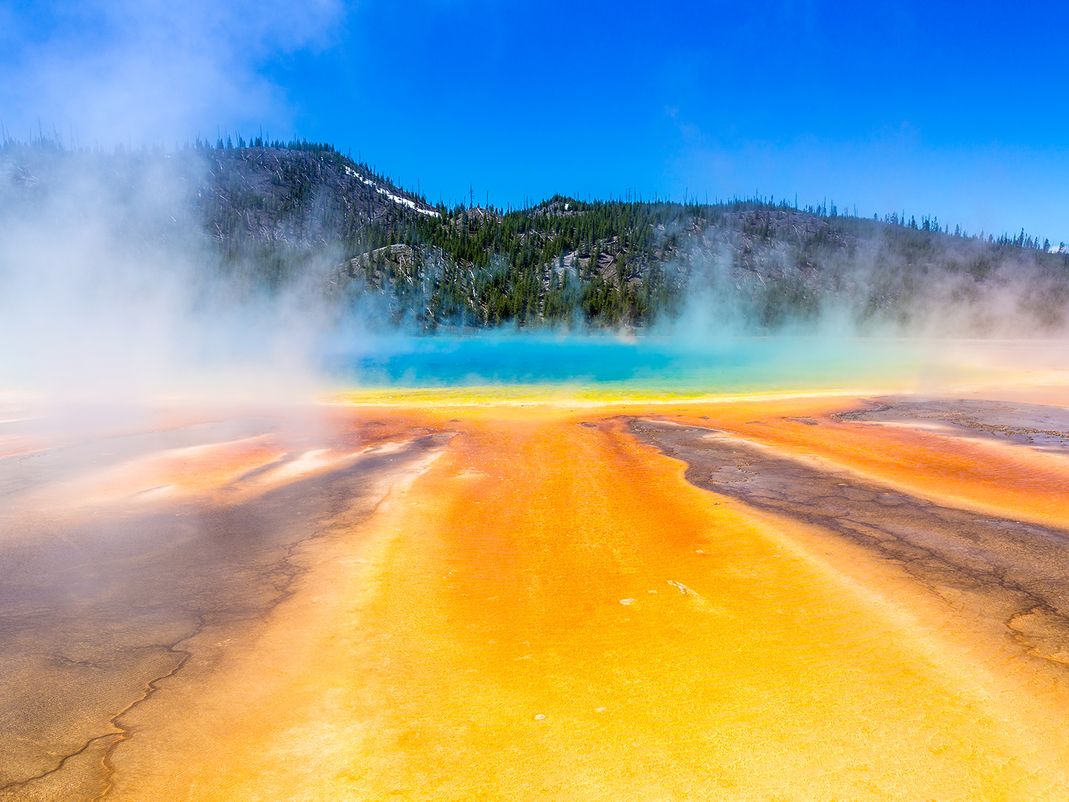
Yellowstone is home to half of the world's known geothermal features, including geysers, hot springs, fumaroles, and mud pots. The most famous is Old Faithful, a geyser that erupts predictably every 60 to 110 minutes, reaching heights of up to 180 feet. Other notable sites include the colourful Grand Prismatic Spring and the bubbling Mud Volcano area. These features are fuelled by a massive underground magma chamber, evidence of Yellowstone’s location atop a supervolcano.
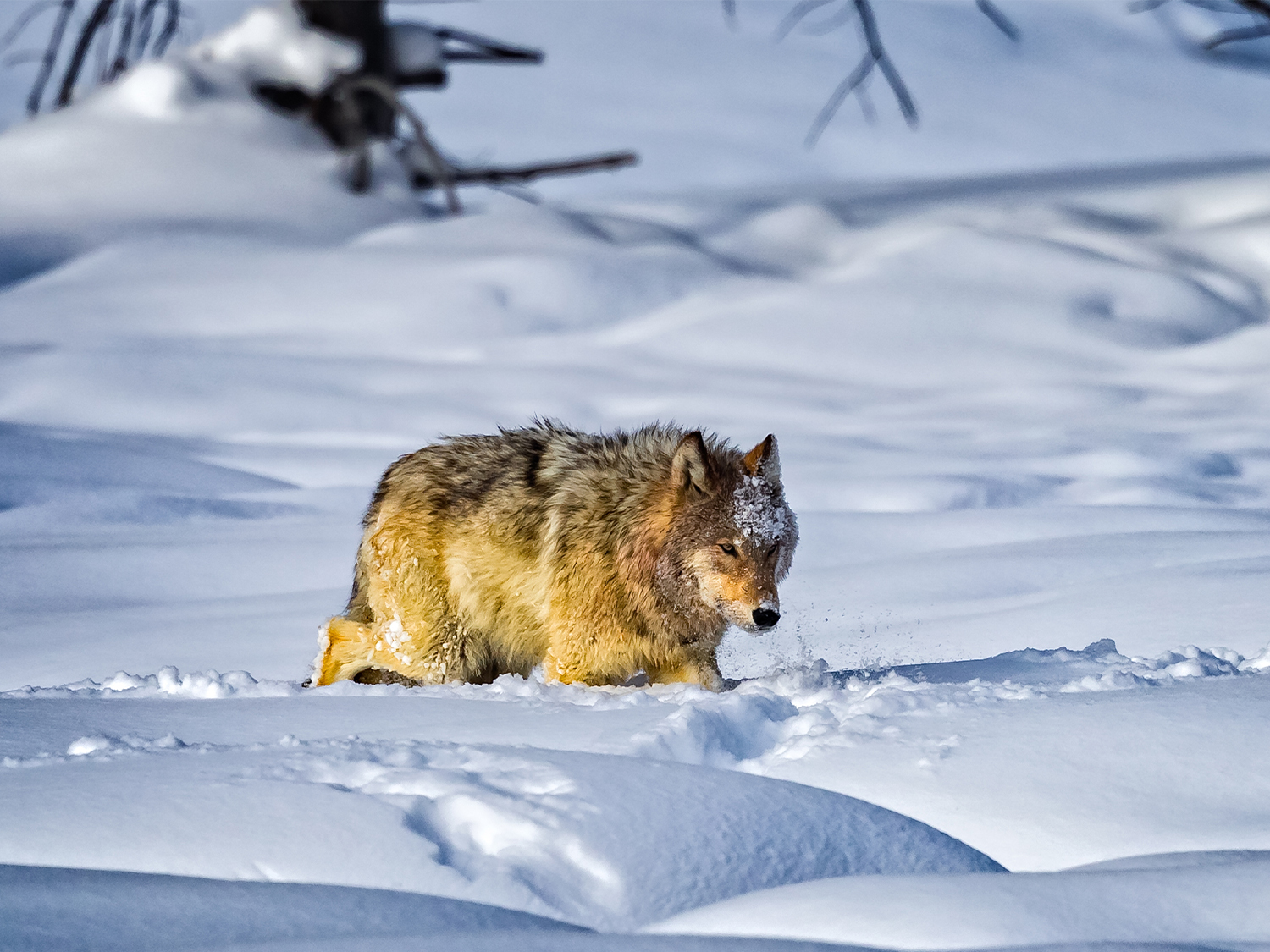
Wildlife
The park hosts a wide array of wildlife, offering one of the best opportunities in North America to observe animals in their natural habitat. Species include bison, elk, grizzly bears, wolves and bald eagles. The Lamar and Hayden Valleys are particularly popular spots for wildlife watching.
Geology
Yellowstone’s unique geology is shaped by volcanic activity. The Yellowstone Caldera, often referred to as a ‘supervolcano’, last erupted approximately 631,000 years ago. Visitors can see evidence of this dynamic geological history in features like the Yellowstone Canyon, with its striking yellow and orange rock formations, and the vast obsidian deposits.
Frequently asked questions
Where is Yellowstone National Park located?
Yellowstone is primarily in northwestern Wyoming, with small portions extending into southern Montana and eastern Idaho.
What is the best time to visit Yellowstone?
The most popular times to visit are late spring (May-June) and early fall (September-October) when the weather is pleasant, wildlife is active, and crowds are manageable. Winter offers unique opportunities for solitude and snowy landscapes, while summer brings warmer weather and fully accessible facilities.
Can I see Old Faithful year-round?
Yes, Old Faithful is active throughout the year. Its eruptions are predictable and occur approximately every 60 to 110 minutes.
Is it safe to visit Yellowstone’s geothermal features?
Yes, as long as visitors stay on designated boardwalks and trails. The ground around geothermal areas is fragile and potentially dangerous. Always follow posted safety guidelines.
What should I pack for a trip to Yellowstone?
Essentials include layered clothing, sturdy footwear, sunscreen, water bottles, snacks, a map, bear spray (if hiking), and binoculars for wildlife viewing.
Is Yellowstone wheelchair accessible?
Many of Yellowstone's main attractions, including Old Faithful and some visitor centres, are wheelchair accessible. Accessibility information is available at visitor centres and on the park’s official website.
What is the Yellowstone supervolcano, and should I be worried?
Yellowstone sits atop a supervolcano, but scientists monitor it closely and report no signs of imminent eruption. The geothermal activity is a natural and ongoing process.
Grand Canyon National Park
States: Arizona
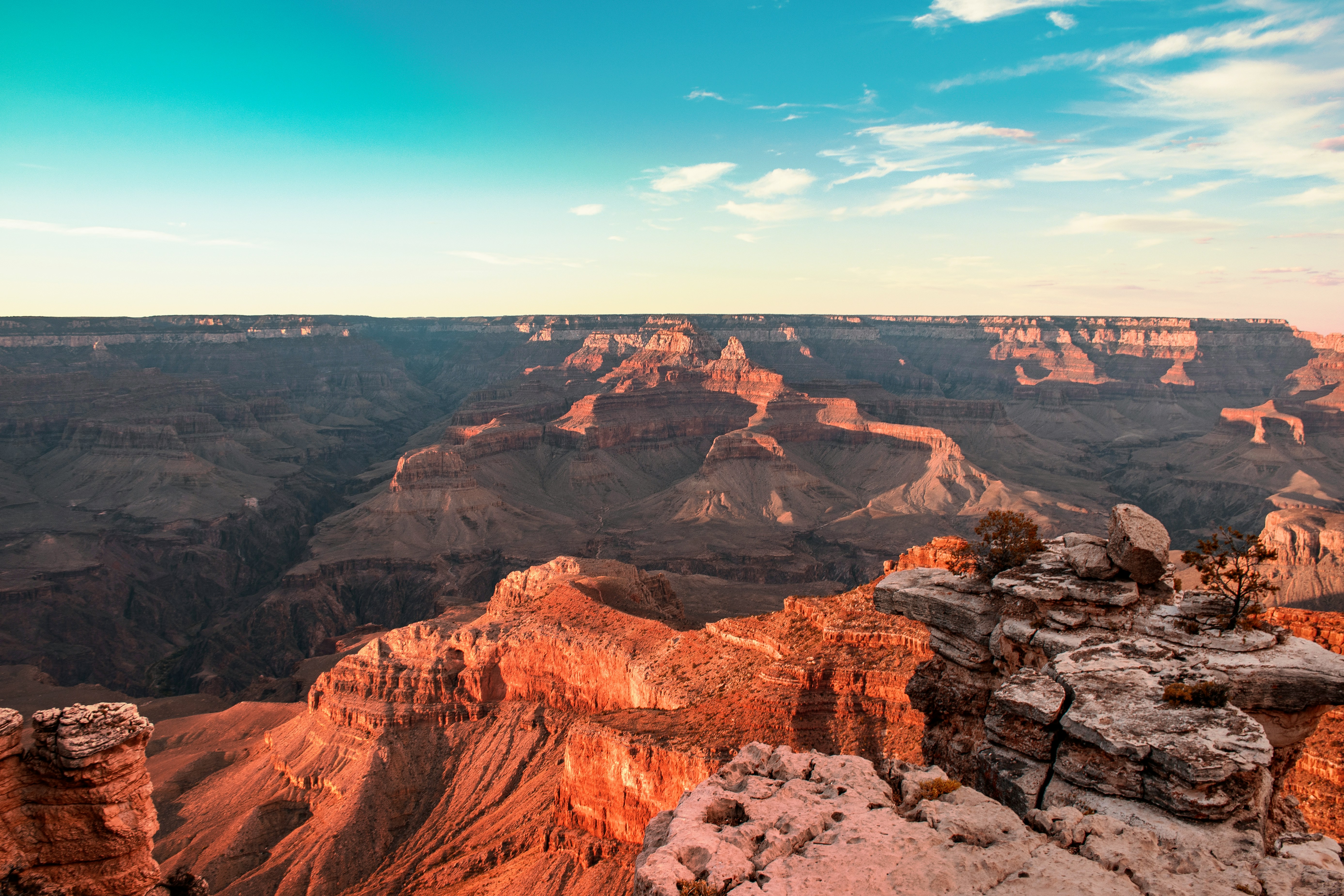
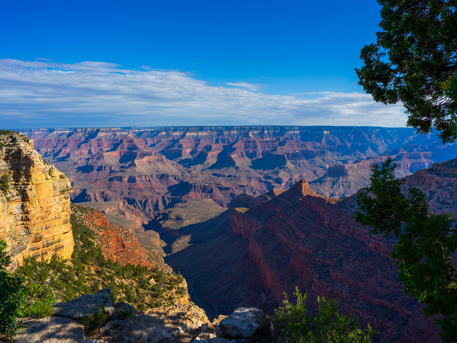
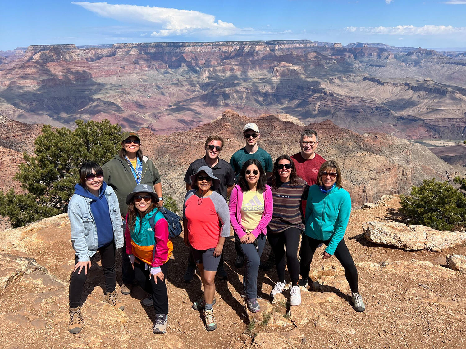
Grand Canyon National Park, located in northern Arizona, is one of the United States' most iconic natural landmarks. Established as a national park in 1919, the Grand Canyon is an incredible 1.2 million acres and contains the 277-mile-long geological marvel carved by the Colorado River over millions of years. The park attracts millions of visitors annually, drawn by its dramatic landscapes, striking geological formations, and opportunities for exploration.
Our guided tours to the Grand Canyon
Super Southwest USA (Camping)

Southwest National Parks Express (Camping)
More about the Grand Canyon
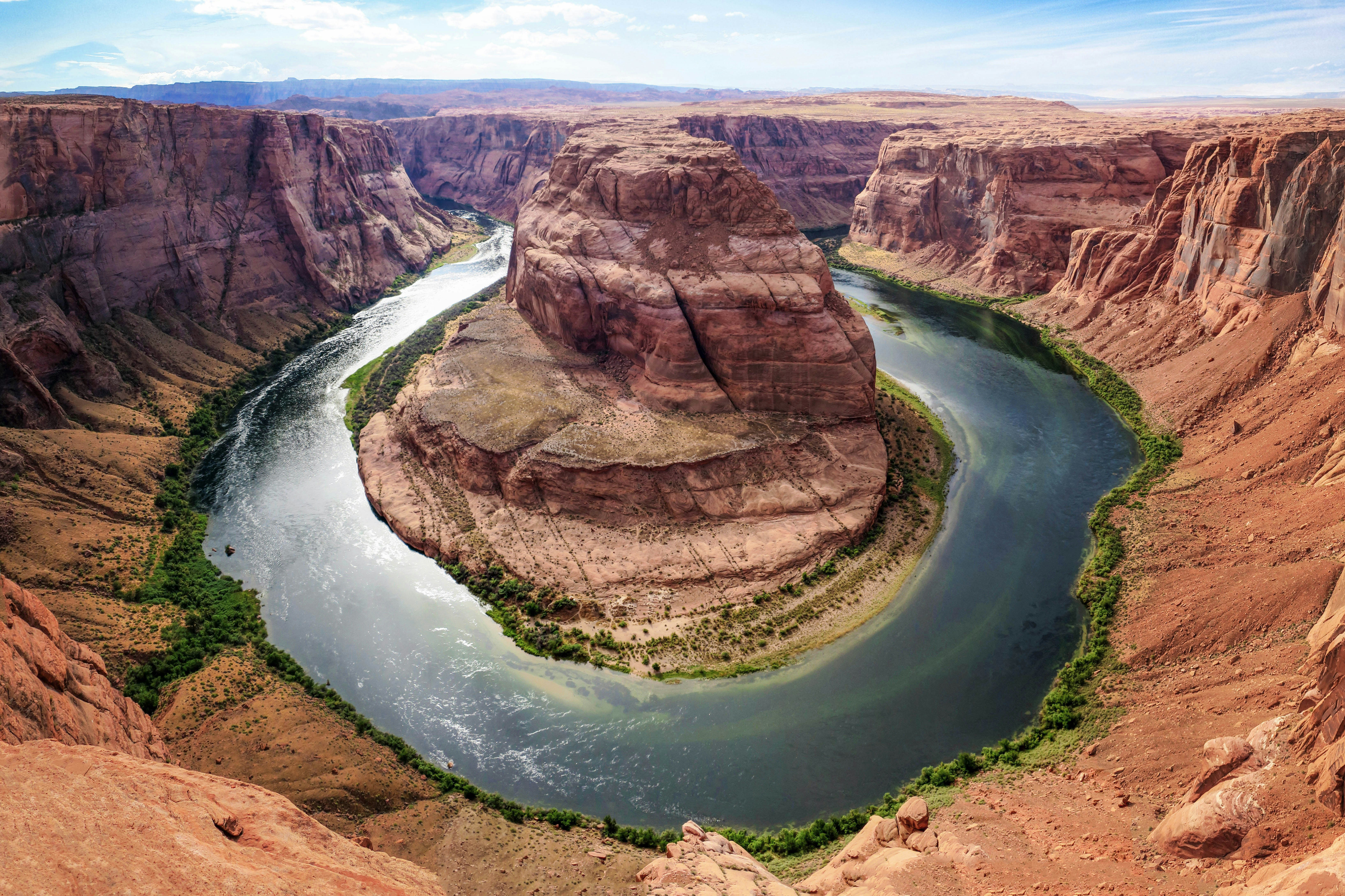
Geological Features
The Grand Canyon is a remarkable display of geological history, with layers of sedimentary rock revealing nearly two billion years of Earth’s past. The Colorado River, which runs through the canyon, has carved this immense landscape over millions of years, creating a series of cliffs, canyons, and rock formations. The canyon’s depth reaches over a mile, and its width varies from 4 to 18 miles. The colours of the canyon walls shift with the light, displaying hues of red, orange, and purple.
Wildlife
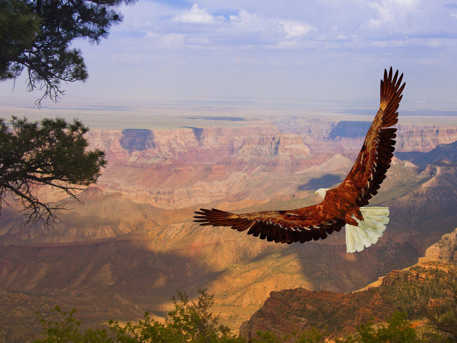
Though may seem inhospitable, the Grand Canyon is home to a diverse range of wildlife. The park hosts a variety of mammals such as mule deer, mountain lions, and bighorn sheep. Birdwatchers can spot species like the California condor, peregrine falcon, and golden eagle. Reptiles, amphibians, and insects also thrive in this environment. The different ecosystems within the park, from desert at the canyon floor to the forest at the rim, support this diversity.
Cultural Importance
The Grand Canyon has significant cultural and spiritual meaning to numerous Native American tribes, including the Havasupai, Hopi, Navajo, and Zuni. Many tribes consider the canyon sacred, and the park works closely with Native American groups to preserve cultural practices and archaeological sites.
Frequently asked questions
Where is the Grand Canyon National Park located?
Grand Canyon National Park is located in northern Arizona, USA. It stretches across over 1.2 million acres of land and is accessible from both the South Rim and North Rim.
What are the best times to visit the Grand Canyon?
The best time to visit are during the spring (March to May) and autumn (September to November) when the weather is mild and the park is less crowded. Sumer (June to August) sees the highest number of visitors and can be quite hot, especially at the canyon floor. Winter (December to February) offers quieter visits, but snow and cold temperatures can impact accessibility.
How deep is the Grand Canyon?
The Grand Canyon is about 1 mile (1.6 km) deep, with the canyon floor being over 7,000 feet (2,130 metres) above sea level in some areas.
Is it safe to hike in the Grand Canyon?
While hiking in the Grand Canyon is safe if proper precautions are taken, it’s important to be well-prepared. The trails can be strenuous, and the weather can change quickly. Hikers should bring plenty of water, wear appropriate footwear, and understand the difficulty of the trail. The National Park Service advises against hiking from the rim to the river and back in one day due to the challenging terrain and heat.
What should I bring with me to the Grand Canyon?
Essential items include:
- Comfortable, sturdy hiking shoes
- Water (at least 2 litres per person)
- Sunscreen, hat, and sunglasses
- Layered clothing (temperatures can vary)
- A camera or binoculars for wildlife and scenic views
- A first aid kit, snacks, and a map of the park
Can I Visit the North Rim of the Grand Canyon year-round?
The North Rim is open seasonally, typically from mid-May to mid-October, due to snow and cold temperatures in the winter months. The South Rim is open year-round.
What wildlife can I see at the Grand Canyon?
The Grand Canyon is home to a wide variety of animals, including mule deer, bighorn sheep, coyotes, mountain lions, and a range of birds like the California condor and peregrine falcon. The park is also home to many smaller animals, including reptiles and insects.
What should I know about visiting the Grand Canyon in winter?
Winter visits to the Grand Canyon are quieter, and the scenery can be breath-taking with snow covering the canyon’s rim. However, temperatures can drop significantly, especially on the rim, and some trails may be icy. The North Rim is closed during winter due to snow, but the South Rim remains accessible year-round.
Can I visit the Grand Canyon if I have limited mobility?
Yes, the Grand Canyon offers several accessible facilities, including viewpoints, paved paths, and some shuttle bus routes. There are also accessible lodging options, bathrooms, and ranger programmes. The South Rim is particularly accommodating for those with limited mobility.
Zion National Park
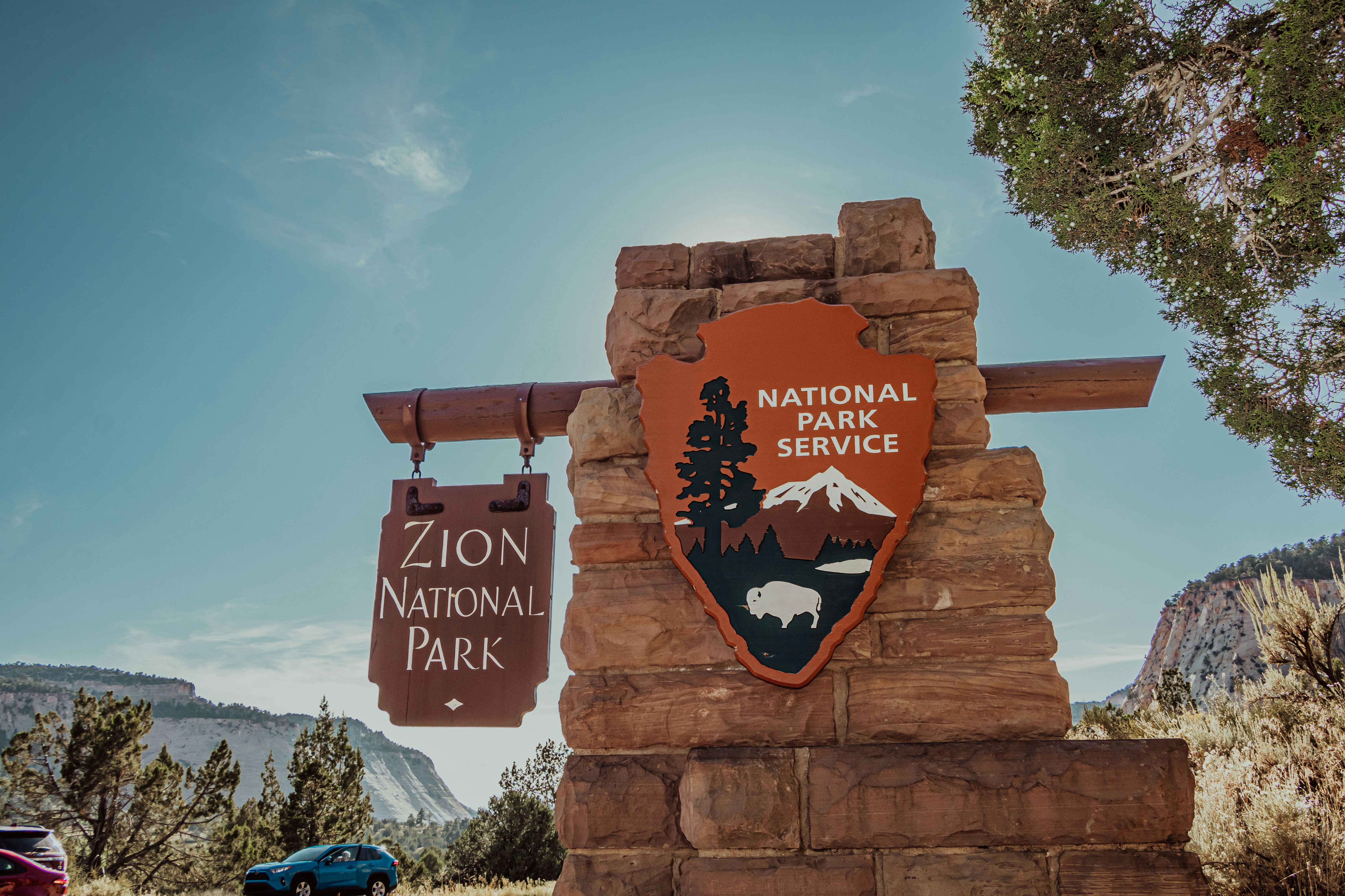
States: Utah
Zion National Park, located in southwestern Utah, is one of the most iconic destinations in the United States, celebrated for its towering sandstone cliffs, narrow canyons, and diverse ecosystems. Established in 1919 as Utah's first national park, it spans approximately 229 square miles and attracts millions of visitors annually.
Our guided tours to Zion National Park
Super Southwest USA (Camping)
Southwest National Parks Express (Camping)
More about Zion National Park

Geological Features
Zion’s landscape is shaped by millions of years of erosion, tectonic activity, and sediment deposition, creating breathtaking formations. The park’s central feature, Zion Canyon, stretches 15 miles long and up to 2,000 feet deep, carved by the Virgin River. The striking red, pink, and cream-colored Navajo sandstone cliffs are a testament to ancient desert sand dunes compacted and shaped over time.
The Narrows: This iconic section of the Virgin River runs through a slot canyon with walls as narrow as 20 feet in some areas and rising up to 1,000 feet. Hiking The Narrows often involves wading or even swimming, offering a unique way to explore the park.
Angels Landing: A world-famous hike, Angels Landing is known for its steep switchbacks, exposed ridgelines, and breathtaking views from the summit, sitting 1,488 feet above the canyon floor.
Kolob Canyons: Located in the northwest corner of the park, this area showcases striking red cliffs and offers solitude away from Zion Canyon’s crowds.
Checkerboard Mesa: A sandstone hill with distinctive crosshatch patterns formed by ancient wind and water erosion.
Wildlife and Ecosystems
Zion’s location at the junction of three geographic regions—the Colorado Plateau, Great Basin, and Mojave Desert—creates a remarkable diversity of ecosystems. The park hosts over 1,000 plant species, 291 bird species, 78 mammal species, and 44 reptile and amphibian species.
• Wildlife: Visitors may encounter mule deer grazing in meadows, rock squirrels scurrying along trails, and bighorn sheep navigating the rocky cliffs. Raptors, including peregrine falcons and golden eagles, are often seen soaring overhead. The park is also home to rare species like the endangered California condor.
• Vegetation: The plant life is equally varied, from desert scrub and cactus in lower elevations to pine and juniper forests in higher regions. Hanging gardens, formed by water seeping through sandstone, support lush vegetation in otherwise arid areas.
The Virgin River is a lifeline for the park’s ecosystems, providing water for plants and animals while shaping the landscape through erosion.
Frequently asked questions
When is the best time to visit Zion National Park?
Spring (March-May) and autumn (September-November) offer the best weather and fewer crowds. Summer can be extremely hot, while winter provides a quieter experience with occasional snowfall.
Do I need a permit to hike Angels Landing?
Yes. As of 2022, a permit is required to hike Angels Landing due to the high visitor numbers. Permits are available through a seasonal and daily lottery system.
Is the shuttle system mandatory?
Yes, from March to late November, private vehicles are not allowed on Zion Canyon Scenic Drive. Visitors must use the free shuttle system or bike or walk into the canyon.
Can I swim in the Virgin River?
Swimming is allowed but not recommended due to strong currents and water quality concerns. The river may contain harmful bacteria, so checking conditions before entering is advised.
What should I pack for a visit?
Essentials include water, sunscreen, sturdy hiking shoes, a hat, and layered clothing. If hiking The Narrows, bring water shoes and a walking stick.
What safety precautions should I take?
- Carry plenty of water, especially summer
- Watch for flash flood warnings if hiking in slot canyons
- Stay on designated trails to protect the ecosystem and ensure safety
- Be prepared for sudden weather changes
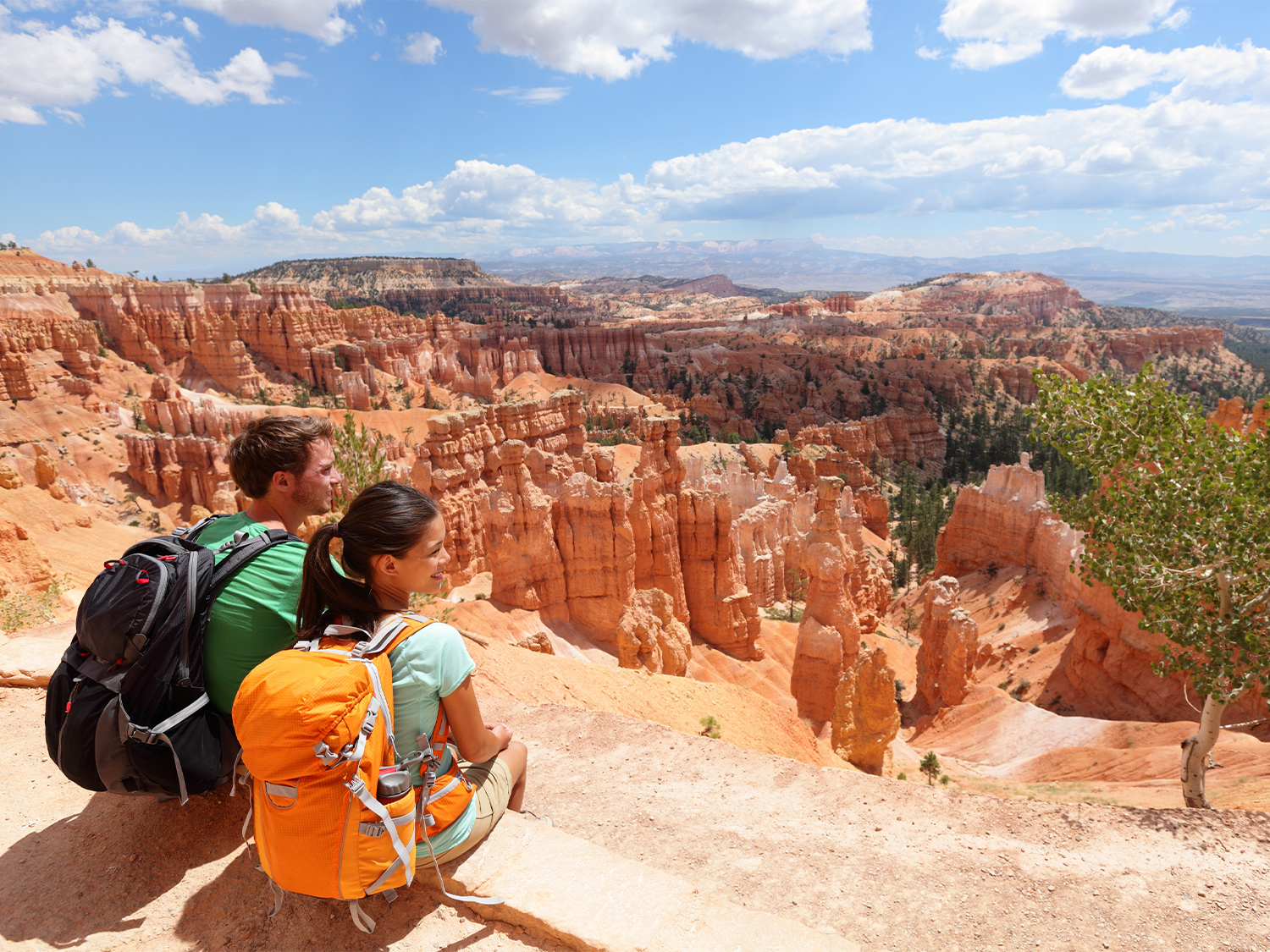
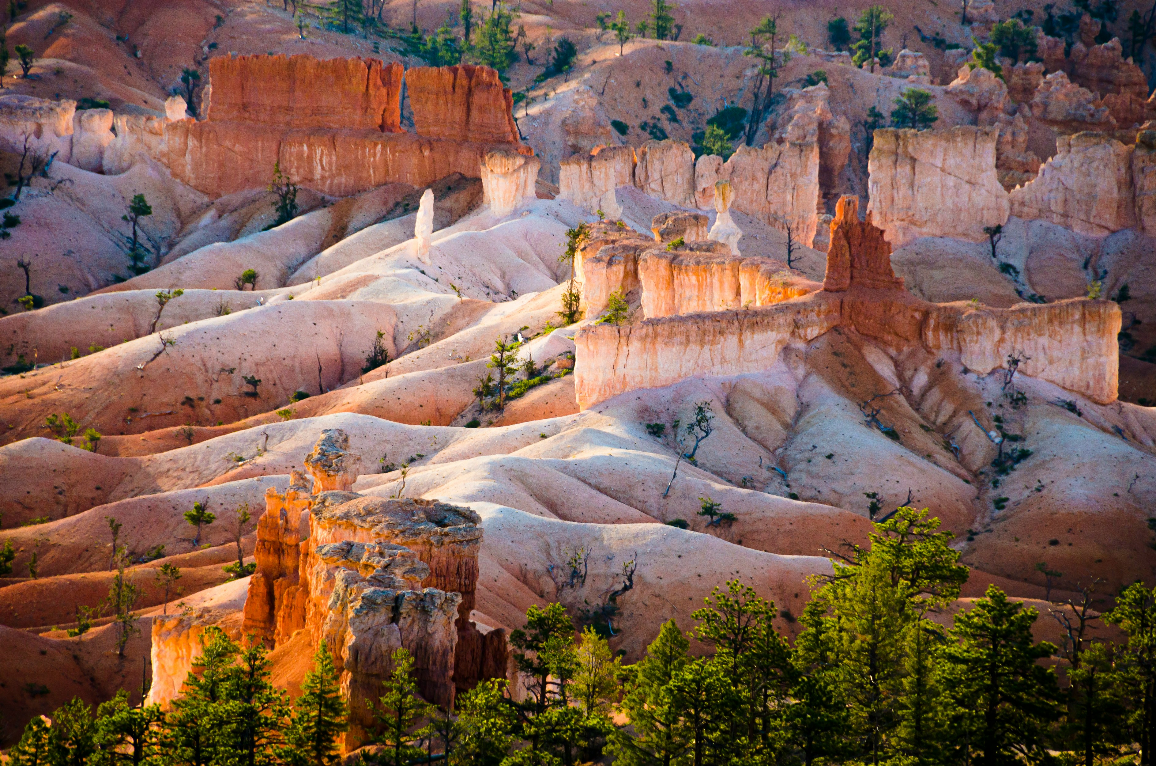
Bryce Canyon National Park
States: Utah
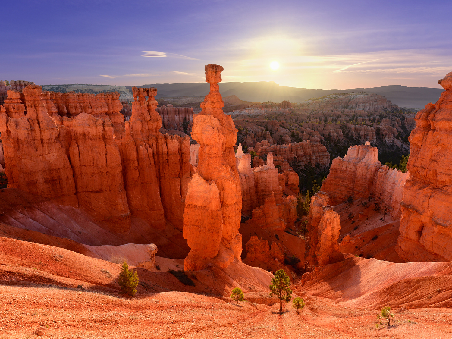
Bryce Canyon National Park, located in southwestern Utah, is known for its intricate rock formations, high plateau landscapes, and panoramic vistas. Covering 25,835 acres, the park is not an actual canyon, but a series of natural amphitheatres carved into the eastern edge of the Paunsaugunt Plateau. The park's distinct geological features, shaped by erosion and weathering over millions of years, make it one of the most visually striking destinations in the United States.
Our guided tours to Bryce Canyon
Super Southwest USA (Camping)
More about Bryce Canyon
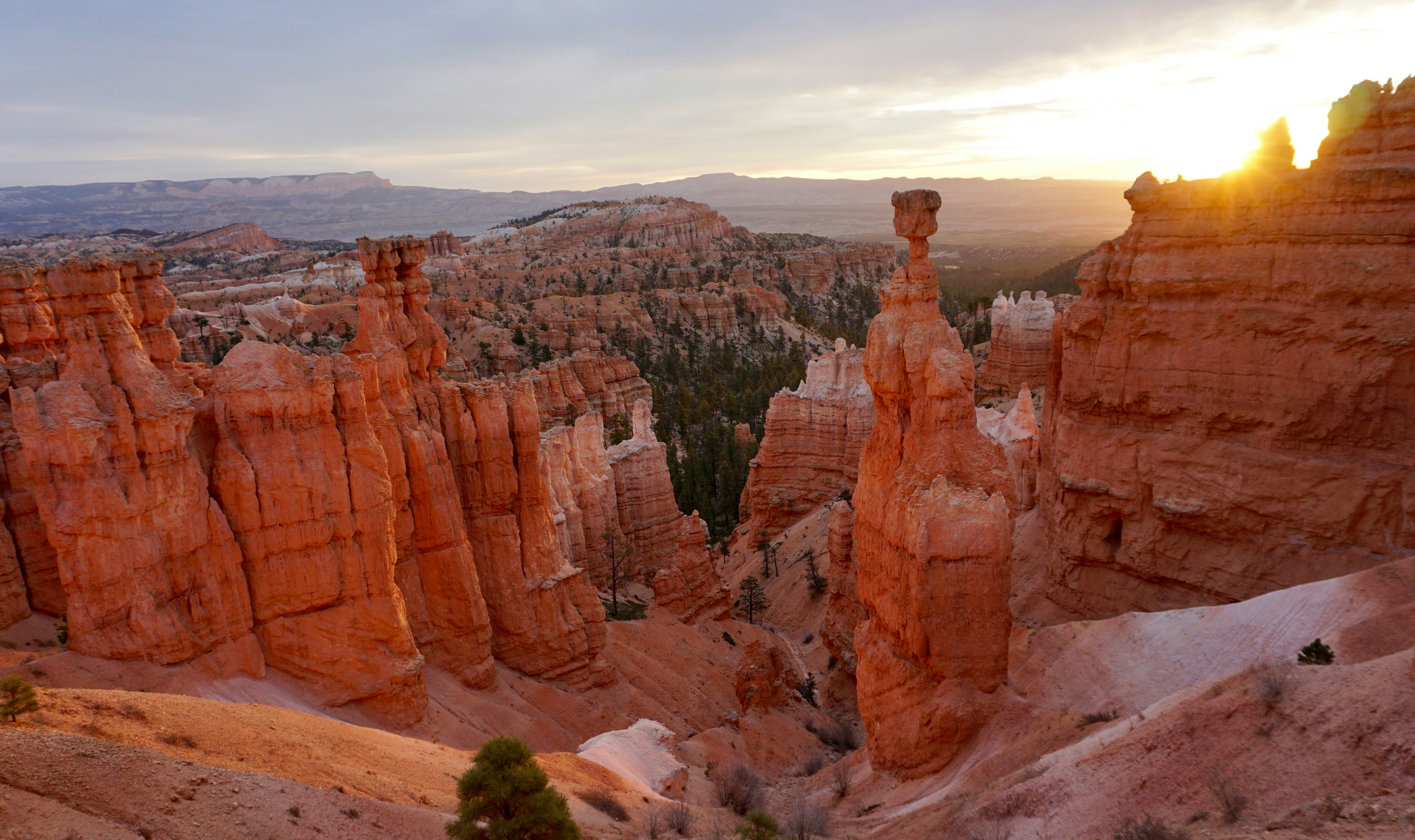
Geology and Rock Formations
Bryce Canyon is renowned for its hoodoos, towering spires of rock created through the continuous cycle of freeze-thaw weathering. These formations develop when water seeps into the cracks in the rock, freezes, expands, and eventually breaks the rock apart. The park’s limestone, siltstone, and sandstone layers, primarily from the Claron Formation, displays vibrant hues ranging from deep reds and oranges to soft pinks and whites due to iron and manganese deposits.
The most famous section of the park is the Bryce Amphitheatre, a vast collection of hoodoos and ridges stretching for 12 miles. Other significant areas include Fairyland Canyon, Paria View, and Natural Bridge, each showcasing unique rock formations and erosion patterns.
Elevation and Climate
Bryce Canyon sits at elevation ranging from 6,600 to 9,115 feet, with its highest point at Rainbow Point. This elevation contributes to dramatic temperatures fluctuations and a semi-arid climate, characterized by warm summers and cold, snowy winters.
- Summers: June to August – High range from 70–80°F (21–27°C), with cooler nights
- Winters: December to February – Temperatures often drop below freezing, with frequent snowfall.
- Spring and Autumn: Unpredictable weather, ranging from mild days to sudden snowstorms.
Wildlife and Ecosystems
Despite its rugged terrain, Bryce Canyon supports diverse ecosystems, ranging from Ponderosa pine forests to alpine meadows. The park is home to over 200 species of birds, 16 species of reptiles, and mammals such as mule deer, mountain lions, and pronghorn antelope.
- Birds: Common species include peregrine falcons, Steller’s jays, and the endangered California condor.
- Mammals: Black bears and bobcats are rarely seen, while prairie dogs are frequently spotted in the park’s meadows.
- Plant Life: The park features bristlecone pines, some over 1,500 years old, along with junipers, firs, and sagebrush.
Frequently asked questions
What is the best time to visit Bryce Canyon National Park?
The best time to visit depends on personal preferences:
- Spring (April-June): Milder weather and fewer crowds, but occasional late snow.
- Summer (June-August): Warm days, busiest season, ideal for hiking.
- Autumn (September- October): Pleasant temperatures and fewer visitors.
- Winter (November – March): Snow covered hoodoos offer a unique experience, but some roads and trails may be closed.
What are the most popular hikes in Bryce Canyon?
- Navajo Loop & Queens Garden Trail: It is a 2.9-mile round trip and is the most recommended for first time visitors.
- Fairyland Loop: It is an 8-mile round trip, it is a longer, less crowded hike with stunning views.
- Peekaboo Loop: It is a 5.5-mile round trip, a moderate to strenuous hike with close-up hoodoo views.
Is Bryce Canyon good for stargazing?
Yes! As an International Dark Sky Park, Bryce Canyon offers exceptional night sky visibility. Ranger-led astronomy programs are available, and summer months provide the clearest views.
What wildlife might I see in the park?
Visitors frequently spot mule deer, prairie dogs, and a variety of birds, while mountain lions and black bears are rarely seen.
What should I bring when visiting Bryce Canyon?
- Hiking boots
- Layers of clothing
- Plenty of water
- Sunscreen and sunglasses
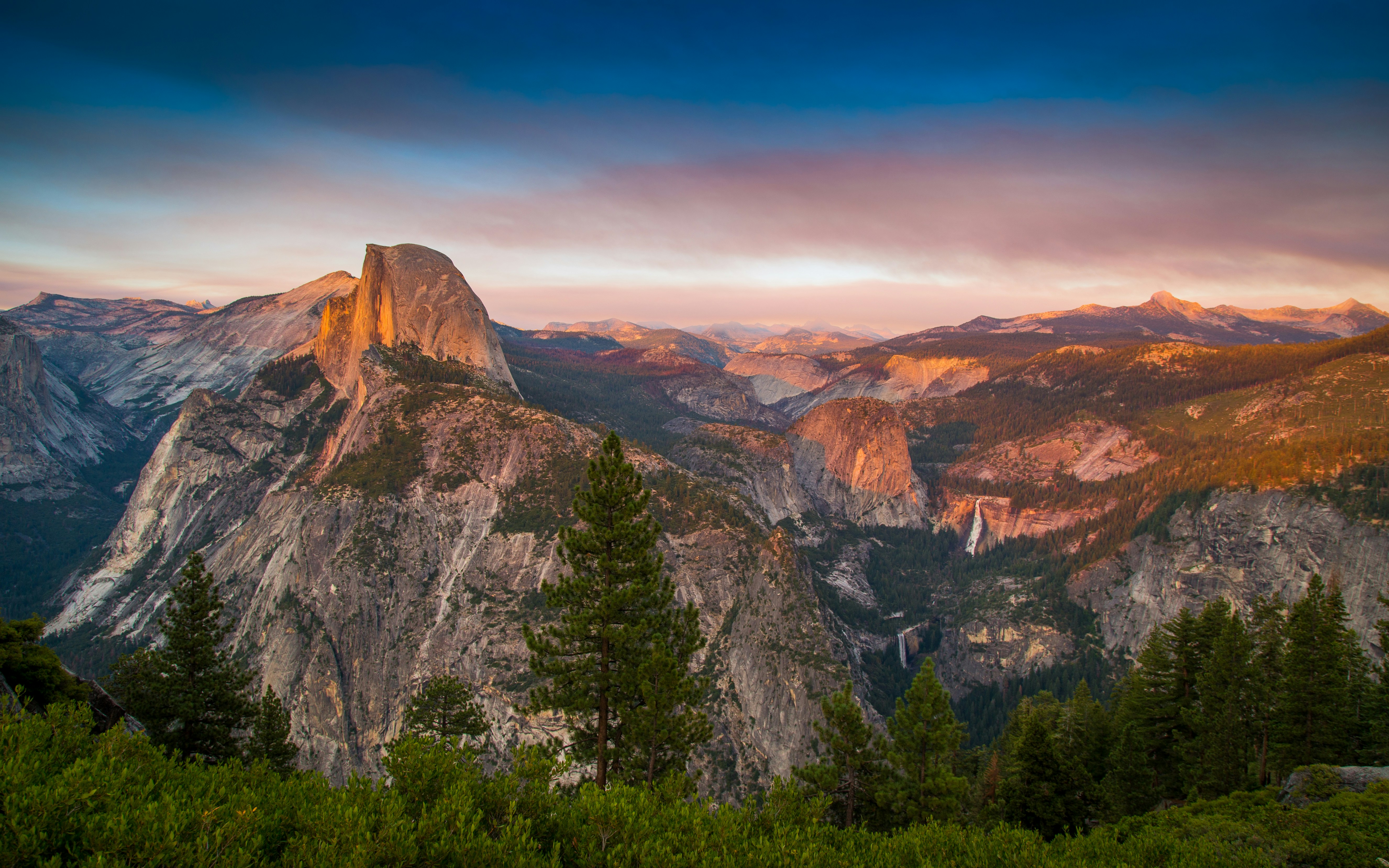
Yosemite National Park
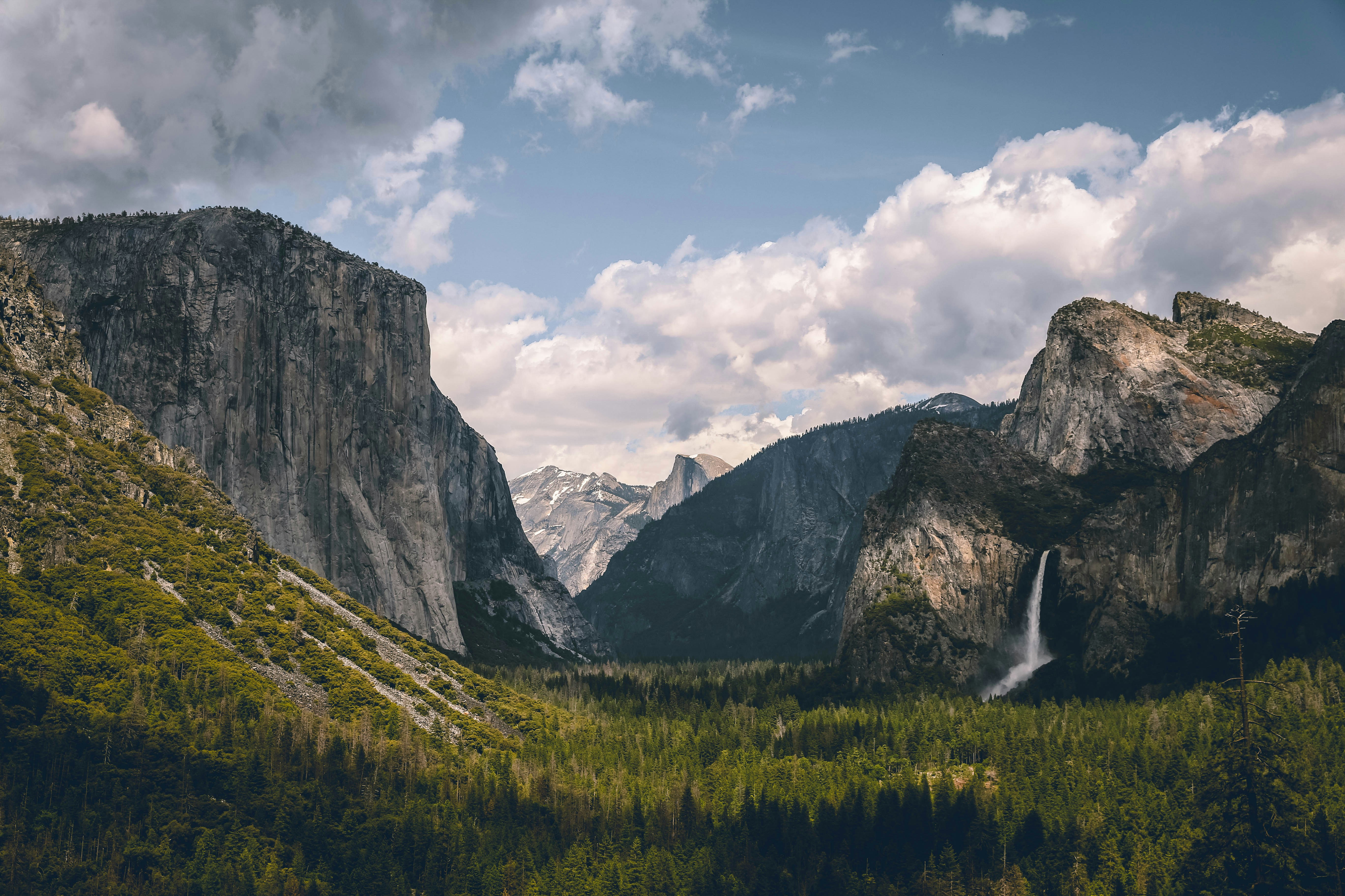
States: California
Yosemite National Park, located in California’s Sierra Nevada Mountains, is known for its towering granite cliffs, waterfalls, ancient sequoia trees, and diverse ecosystems. Established in 1890, it covers approximately 1,187 square miles and attracts millions of visitors annually.
Our guided tours to Yosemite


More about Yosemite National Park
Landmarks and Natural Features
Yosemite’s landscape is dominated by massive granite formations, including El Capitan, a nearly 3,000-foot vertical rock face popular among climbers, and Half Dome, a distinctively shaped peak that offers a challenging hike. The Yosemite Valley provides breathtaking views of these formations along with meadows, forests, and the winding Merced River.
The park is also home to several waterfalls, including Yosemite Falls, one of the tallest in North America at 2,425 feet, and Bridalveil Fall, known for its misty, flowing cascade.
Giant Sequoias
One of Yosemite’s most remarkable features is its groves of ancient giant sequoias, some of the largest and oldest trees in the world. The Mariposa Grove, the largest in the park, contains over 500 mature sequoias, including the famous Grizzly Giant and California Tunnel Tree.
Wildlife
Yosemite supports a variety of wildlife, including black bears, mule deer, mountain lions, and bobcats. Birdwatchers can spot species such as peregrine falcons, great gray owls, and Steller’s jays. The park’s diverse habitats, ranging from lowland meadows to alpine tundra, contribute to its ecological richness.
Frequently asked questions
When is the best time to visit Yosemite National Park?
The park is open year-round, but the best time to visit depends on interests. Spring (April–June) offers waterfalls at peak flow, summer (July–August) provides the best hiking conditions, fall (September–November) has fewer crowds, and winter (December–March) is ideal for snow activities.
What are the best hikes for beginners?
Easy and scenic hikes include Lower Yosemite Falls Trail, Mirror Lake Trail, and Bridalveil Fall Trail.
How high is Half Dome, and can anyone climb it?
Half Dome rises 8,839 feet above sea level. The hike is strenuous, requiring a permit and a final ascent up cable handrails.
What should I do if I see a bear?
Maintain a safe distance, do not feed wildlife, and store food in bear-proof containers. If a bear approaches, make noise and back away slowly.
What should I pack for a visit?
Essentials include layered clothing, sturdy hiking shoes, a refillable water bottle, sunscreen, a map, and bear-proof food storage if camping.
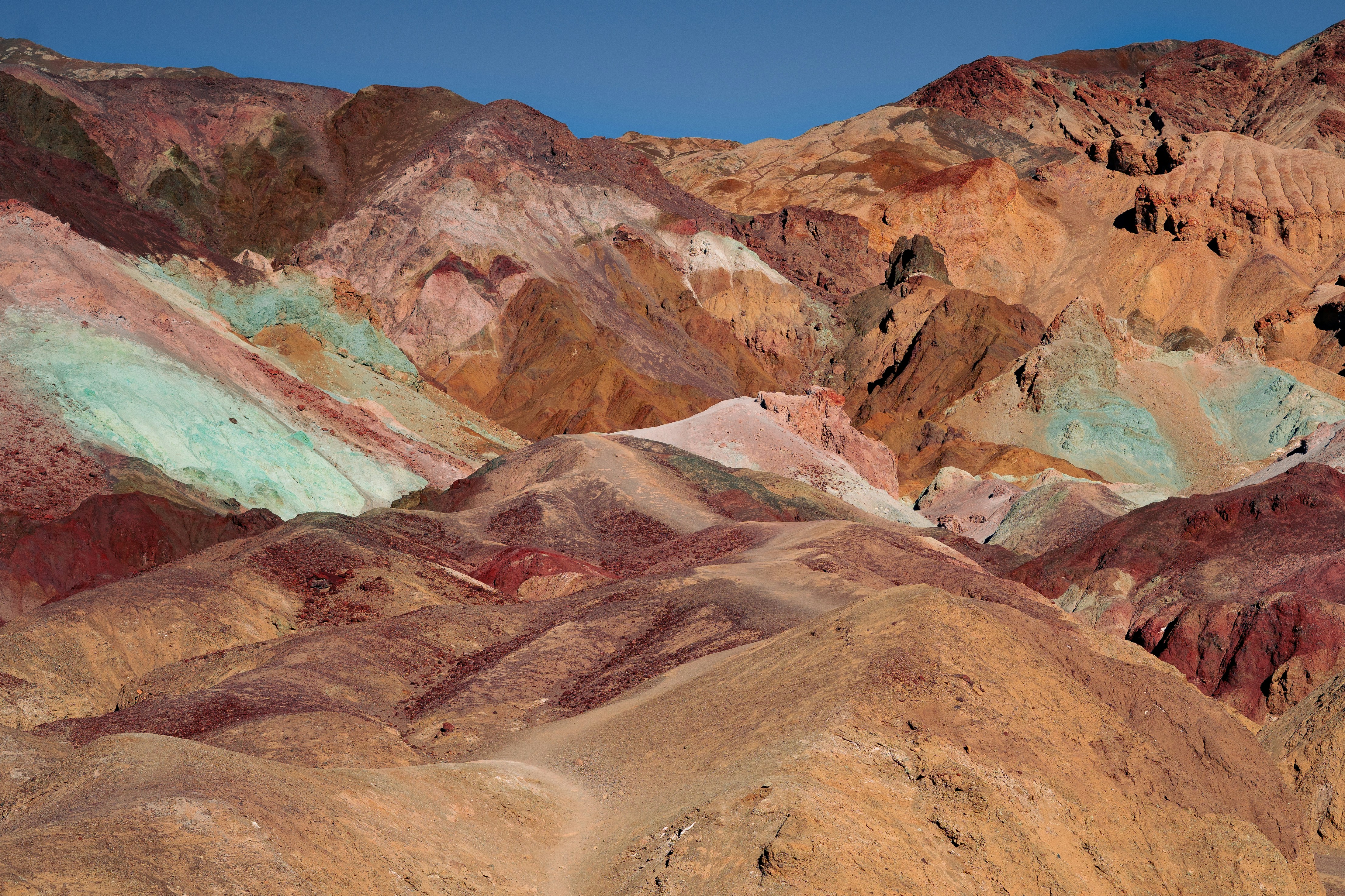
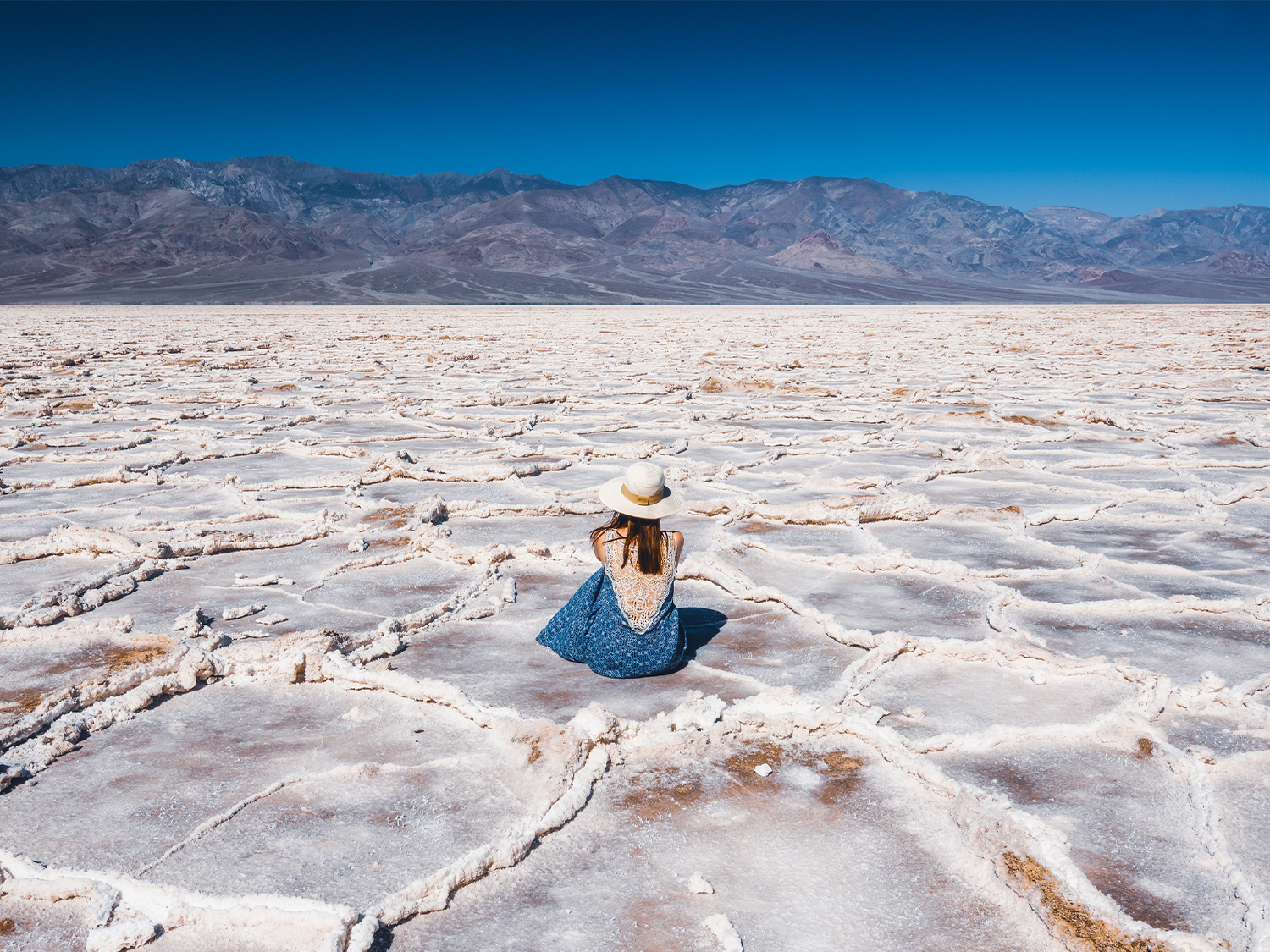
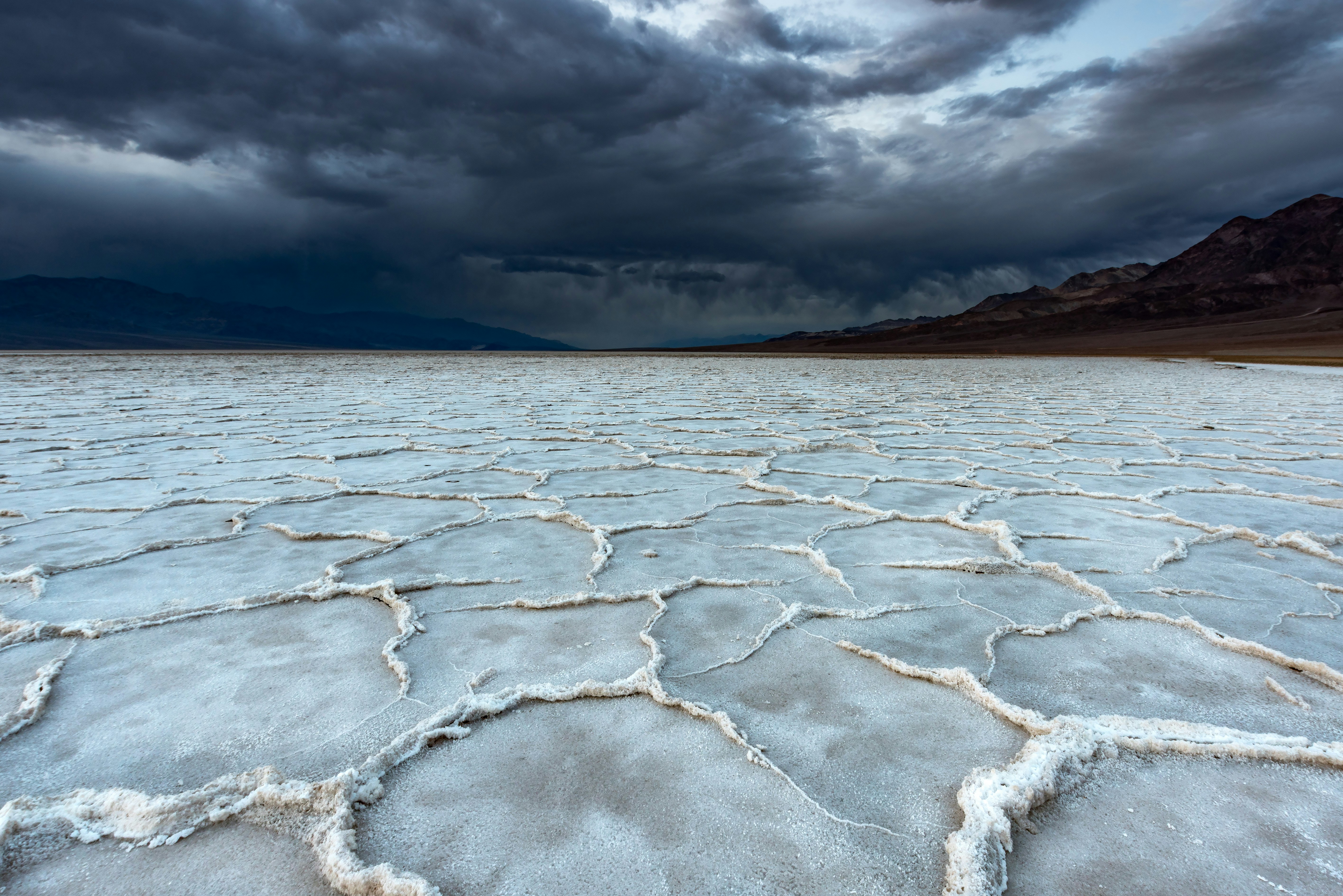
Death Valley National Park
States: California, Nevada
Death Valley National Park, located in eastern California and extending into Nevada, is the hottest, driest, and lowest national park in the United States. Covering approximately 3.4 million acres, it features extreme landscapes, unique geological formations, and diverse ecosystems adapted to harsh desert conditions.
Our guided tours to Death Valley
Yellowstone & Yosemite (Camping/Hotel)
Las Vegas to San Francisco (Camping)
Wild West Encompassed (Camping)
Death Valley & Yosemite (Camping)
More about Death Valley
Climate and Geography
Death Valley is known for its extreme temperatures, with summer highs frequently exceeding 120°F (49°C). It holds the record for the highest temperature ever recorded on Earth—134°F (56.7°C) at Furnace Creek in 1913. The park's elevation varies dramatically, from Badwater Basin, the lowest point in North America at 282 feet below sea level, to Telescope Peak, which rises to 11,043 feet.
Geological Features
The park showcases striking geological formations shaped by erosion, tectonic activity, and ancient lake beds. Notable sites include:
• Badwater Basin – A vast salt flat formed by evaporated ancient lakes.
• Mesquite Flat Sand Dunes – Rolling sand dunes that create stunning desert landscapes.
• Zabriskie Point – A viewpoint overlooking colorful, eroded badlands.
• Artist’s Palette – A hillside displaying vibrant mineral deposits.
• Ubehebe Crater – A large volcanic crater formed by a steam explosion.
Wildlife and Adaptations
Despite its harsh conditions, Death Valley supports a variety of life. Species such as desert bighorn sheep, coyotes, kangaroo rats, and roadrunners have adapted to survive with limited water. Wildflowers bloom briefly in spring after rare rainfalls, adding bursts of colour to the desert.
Frequently asked questions
When is the best time to visit Death Valley?
The best time to visit is from late fall to early spring (November to March), when temperatures are cooler and more suitable for outdoor activities. Summer visits are possible but require extreme heat precautions.
How hot does it get in Death Valley?
Temperatures in summer often exceed 120°F (49°C), with ground temperatures reaching even higher. The hottest recorded temperature was 134°F (56.7°C) in 1913.
Is it safe to visit Death Valley?
Yes, but visitors should take precautions, especially in summer. Carry plenty of water, avoid strenuous activities during peak heat, and let someone know your travel plans.
Can I see wildlife in Death Valley?
Yes, despite its harsh conditions, Death Valley is home to desert bighorn sheep, coyotes, kit foxes, and many bird species. Wildlife is most active in the early morning and evening.
What should I bring for a visit?
Essentials include water (at least one gallon per person per day), sun protection (hat, sunglasses, sunscreen), sturdy shoes, snacks, and a detailed map, as cell service is limited.
Can I visit Death Valley in the summer?
Yes, but extreme heat requires extra caution. Visitors should stay in air-conditioned areas, explore in the early morning or evening, and avoid hiking during the day.
Is Death Valley a good place for stargazing?
Yes, it is designated an International Dark Sky Park, offering some of the best night sky views in the U.S. The best time for stargazing is on clear, moonless nights.
How far is Death Valley from major cities?
Death Valley is about 2 hours from Las Vegas and 4.5 hours from Los Angeles by car. The closest major airport is in Las Vegas.
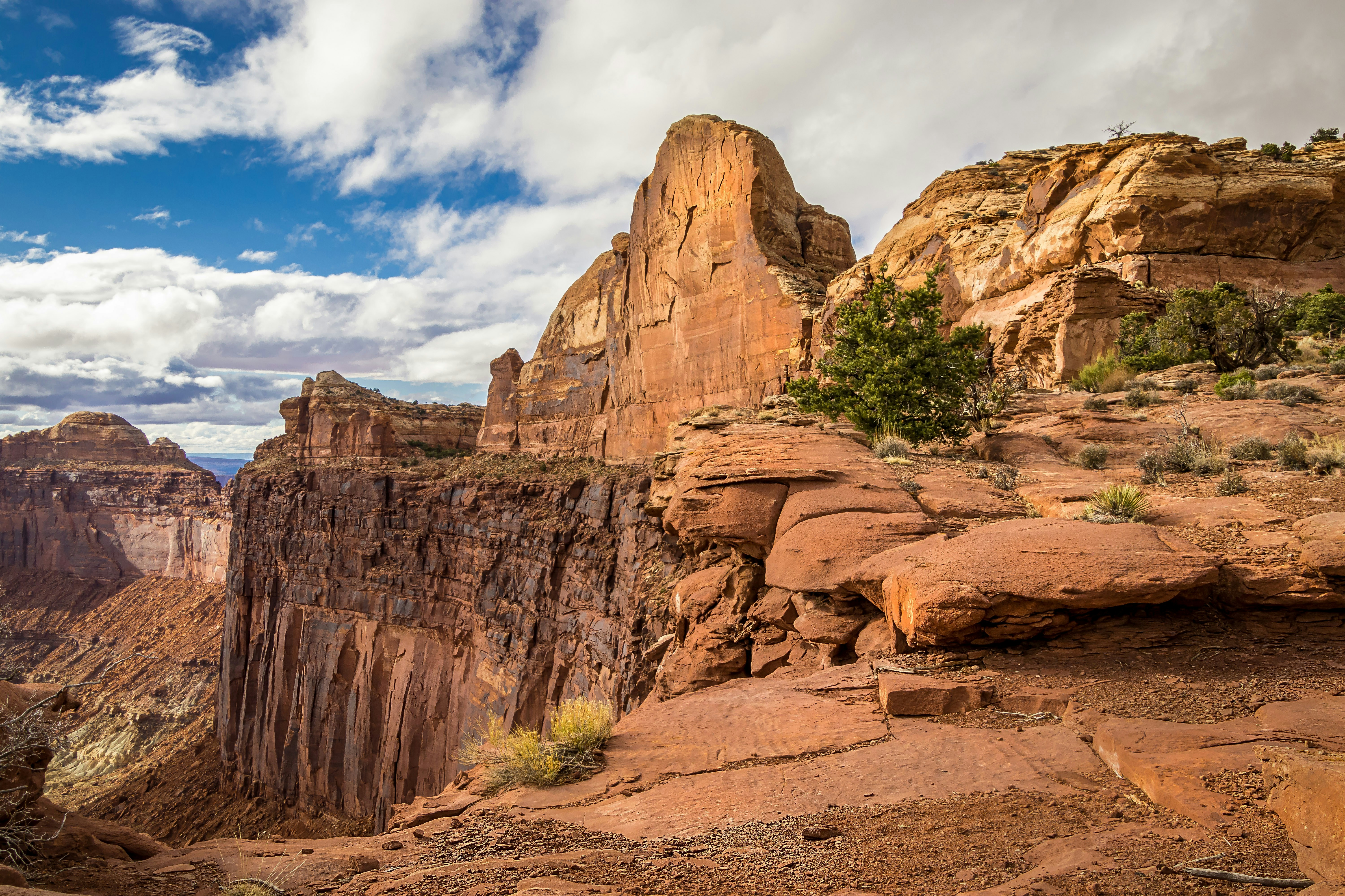
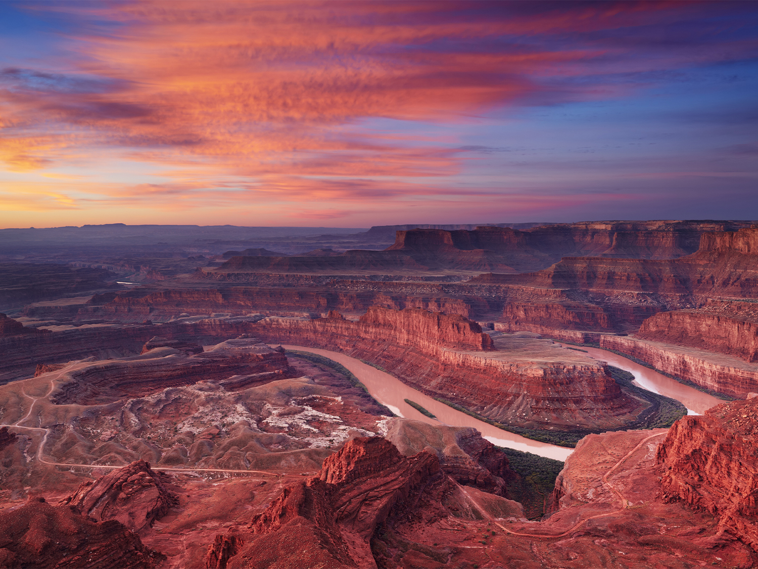
Canyonlands National Park
States: Utah
Canyonlands National Park, located in southeastern Utah, is known for its dramatic desert landscapes, deep canyons, towering mesas, and unique rock formations. Established in 1964, the park covers over 337,000 acres and is divided into four districts, each offering distinct geological and recreational experiences.
Our guided tours to Canyonlands National Park
Super Southwest USA (Camping)

Wild West Encompassed (Camping)
More about Canyonlands National Park
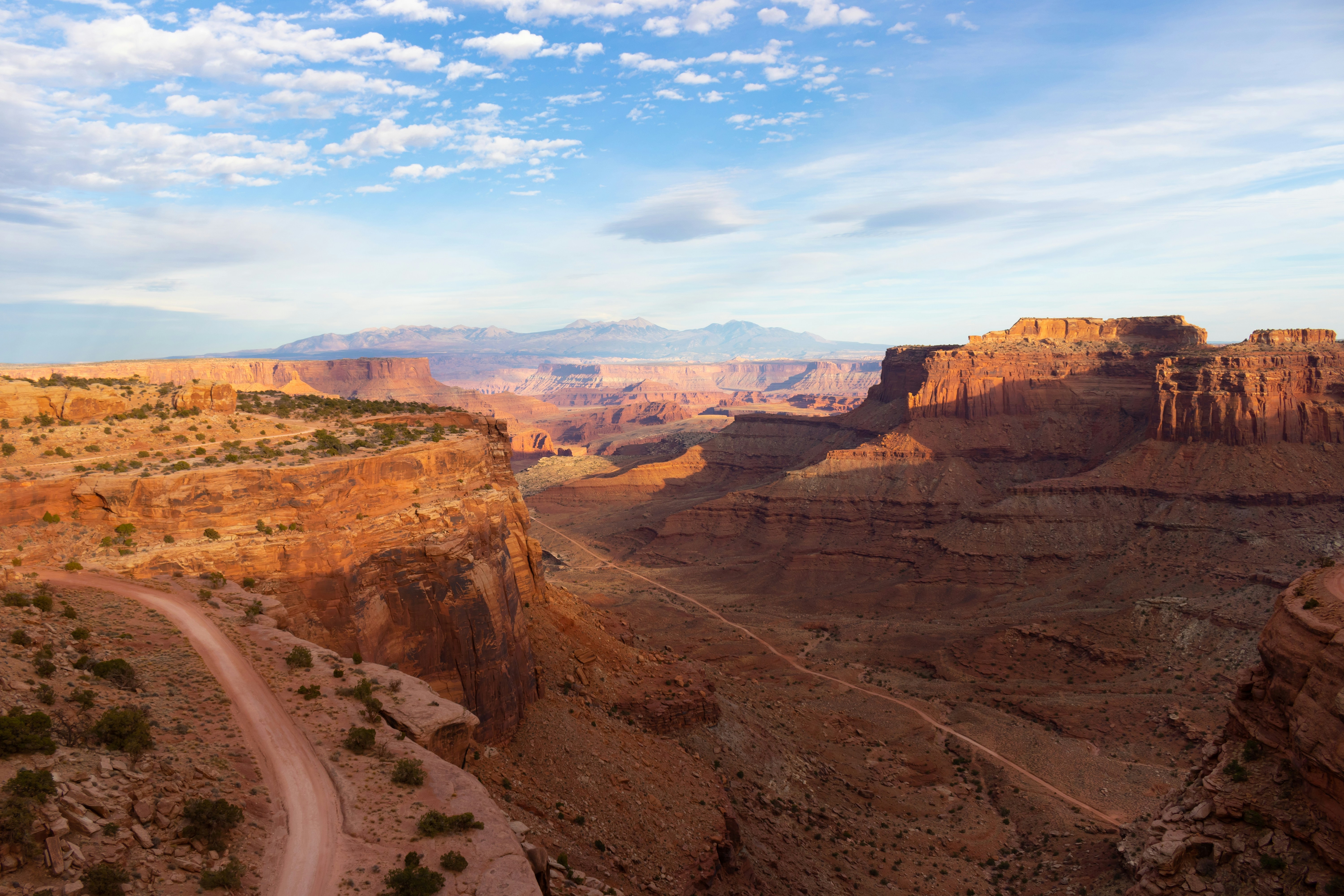
Districts and Landscapes
Canyonlands is divided into four main regions, separated by the Colorado and Green Rivers:
• Island in the Sky – A vast, high mesa with panoramic viewpoints, including the famous Mesa Arch, which frames sunrise views over deep canyons. The Grand View Point overlook offers one of the most expansive vistas in the park.
• The Needles – Named for its colorful sandstone spires, this district features rugged hiking trails, slot canyons, and ancient rock art, including petroglyphs left by Indigenous peoples.
• The Maze – The most remote and challenging area, known for its labyrinth-like canyons and difficult terrain, appealing to experienced backcountry adventurers.
• The Rivers (Colorado and Green) – These waterways carve through the park, creating deep gorges and supporting riparian ecosystems. Whitewater rafting and kayaking are popular activities.
Geology
The park’s landscape was shaped over millions of years by erosion, primarily from water and wind. Rock layers reveal a geological history dating back hundreds of millions of years. Natural arches, towering buttes, and unique formations such as Upheaval Dome, a mysterious crater-like feature, add to the park’s geological intrigue.
Wildlife
Despite its harsh desert environment, Canyonlands supports a variety of wildlife, including bighorn sheep, coyotes, desert cottontails, and a range of bird species. The sparse vegetation includes juniper trees, sagebrush, and hardy desert plants adapted to the arid climate.
Frequently asked questions
Where is Canyonlands National Park located?
Canyonlands is in southeastern Utah, near the town of Moab.
What makes Canyonlands unique?
The park is known for its deep canyons, towering mesas, remote backcountry, and famous landmarks like Mesa Arch and Upheaval Dome.
What are the four districts of Canyonlands?
• Island in the Sky – Easy access, scenic overlooks.
• The Needles – Unique rock formations and hiking trails.
• The Maze – Remote and challenging terrain.
• The Rivers – Colorado and Green Rivers for rafting and kayaking.
When is the best time to visit Canyonlands?
• Spring (March–May) & Fall (September–November): Best for hiking and sightseeing with moderate temperatures.
• Summer (June–August): Very hot; visit early or late in the day.
• Winter (December–February): Cold but offers solitude and unique views.
What wildlife can I see in Canyonlands?
Common sightings include bighorn sheep, coyotes, foxes, lizards, hawks, and eagles.
Arches National Park
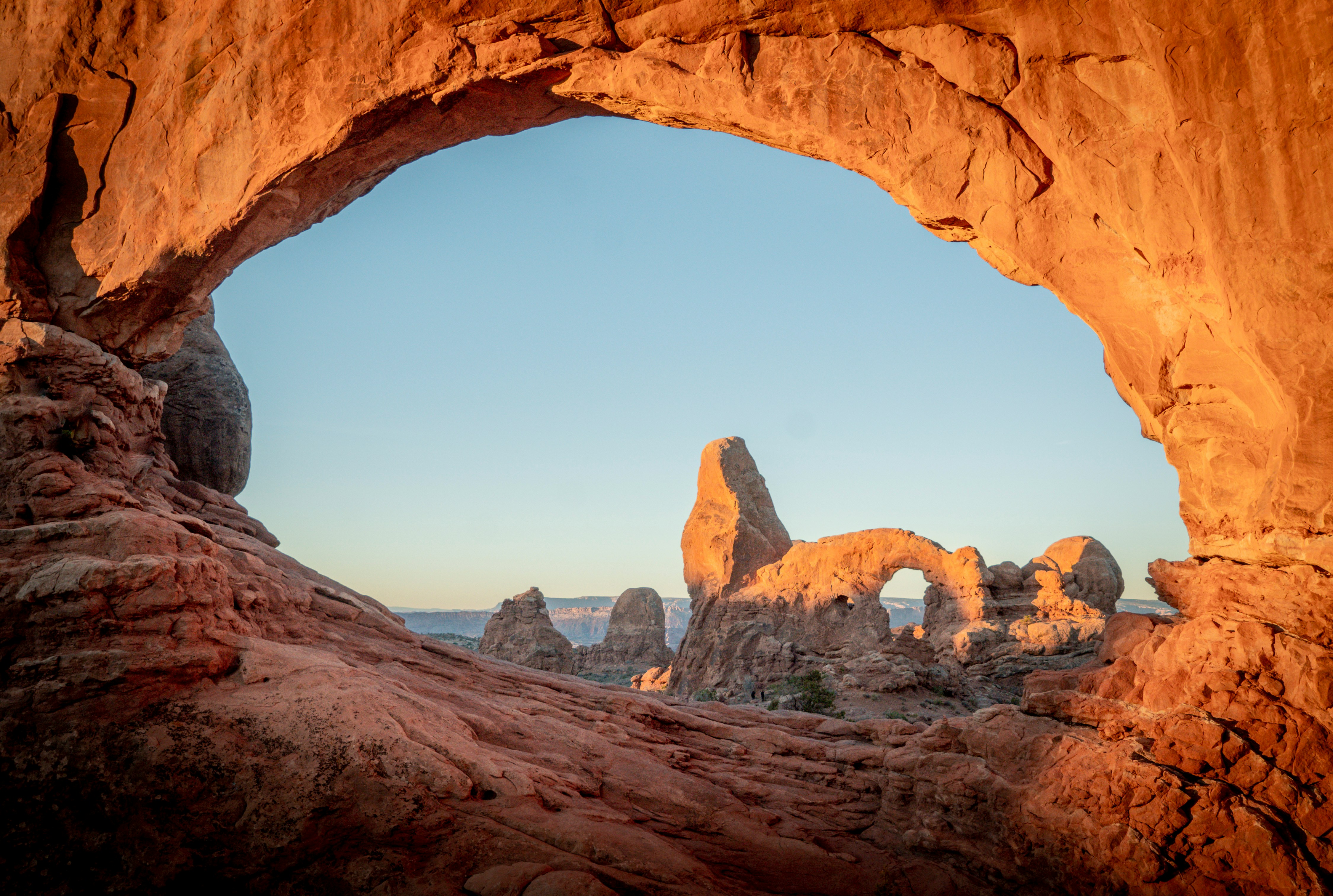
States: Utah
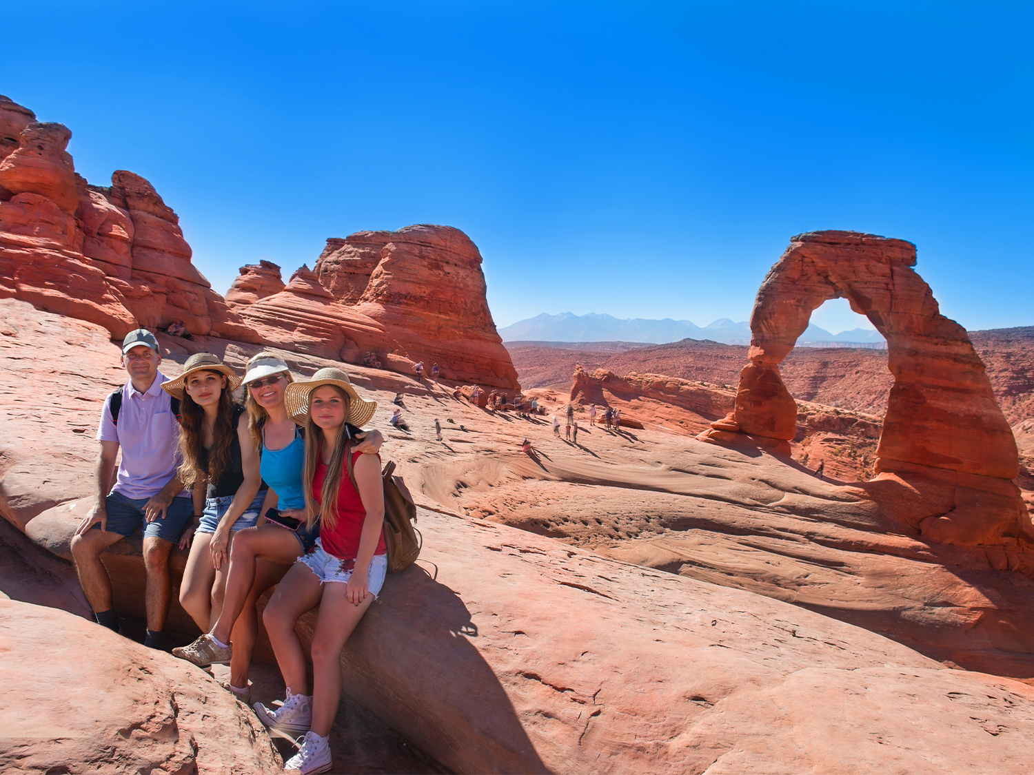
Arches National Park, located in eastern Utah, is famous for its stunning collection of over 2,000 natural sandstone arches, making it one of the most iconic landscapes in the American Southwest. Established as a national park in 1971, Arches spans approximately 76,000 acres and showcases the power of erosion and time in shaping unique geological formations.
Our guided tours to Arches National Park
Super Southwest USA (Camping)
Wild West Encompassed (Camping)
More about Arches National Park
Geological Features
The park’s dramatic landscape is dominated by its arches, which are formed through a combination of erosion, weathering, and the unique properties of the Entrada and Navajo Sandstone. Delicate Arch, the park’s most famous feature, stands as a symbol of Utah, often appearing on postcards and license plates. Other notable formations include Landscape Arch, one of the longest arches in the world, and Double Arch, which features two massive, interconnected arches.
Wildlife
Despite the arid conditions, Arches is home to a variety of wildlife, including species such as mule deer, rock wren, desert cottontail rabbits, and coyotes. The park is also an excellent spot for birdwatching, with numerous species of eagles, falcons, and songbirds. Visitors might also encounter reptiles like desert tortoises and various lizards that thrive in the warm, dry environment.
Geology
The formation of Arches began over 300 million years ago, during the time of the late Jurassic period. The area's unique landscape developed through a process of tectonic shifts, erosion from wind and water, and the expansion of salt deposits beneath the surface. The geological forces have combined to create a breathtaking array of arches, spires, and pinnacles.
Frequently asked questions
What is the best time to visit Arches National Park?
The best time to visit is in the spring (April to May) and fall (September to October), when temperatures are milder. Summer can be extremely hot, with daytime temperatures often exceeding 100°F (38°C), making early mornings or evenings ideal for visiting. Winter can be cold, but it offers fewer crowds and unique snowy landscapes.
What are the best hikes in Arches National Park?
Some of the top hikes include:
• Delicate Arch Trail (3 miles, moderate): The most famous arch in the park, best seen at sunset.
• Landscape Arch Trail (1.6 miles, easy): A relatively short trail to one of the longest arches in the world.
• Devil’s Garden Trail (7.2 miles, difficult): A longer, more challenging hike that passes several arches.
• Fiery Furnace (2.5 miles, moderate to difficult): Requires a ranger-led tour or permit, known for its narrow passages and stunning rock formations.
What should I bring to Arches National Park?
Essential items include plenty of water, sunscreen, a hat, sturdy shoes for hiking, and layers for temperature fluctuations. Be prepared for the desert climate, which can be extremely hot during the day and cold at night.
Can I go stargazing in Arches National Park?
Yes! Arches is a designated dark sky park, and stargazing is a popular activity. The park offers stunning views of the night sky, especially in the winter and early spring. Keep an eye out for ranger-led night programs during the summer months.
Are there any safety tips for visiting Arches National Park?
Always carry plenty of water, wear appropriate footwear, and avoid hiking during the hottest parts of the day. Be aware of the weather, as sudden storms can occur. Respect wildlife from a distance and remember to stay on designated trails to protect the fragile desert ecosystem.
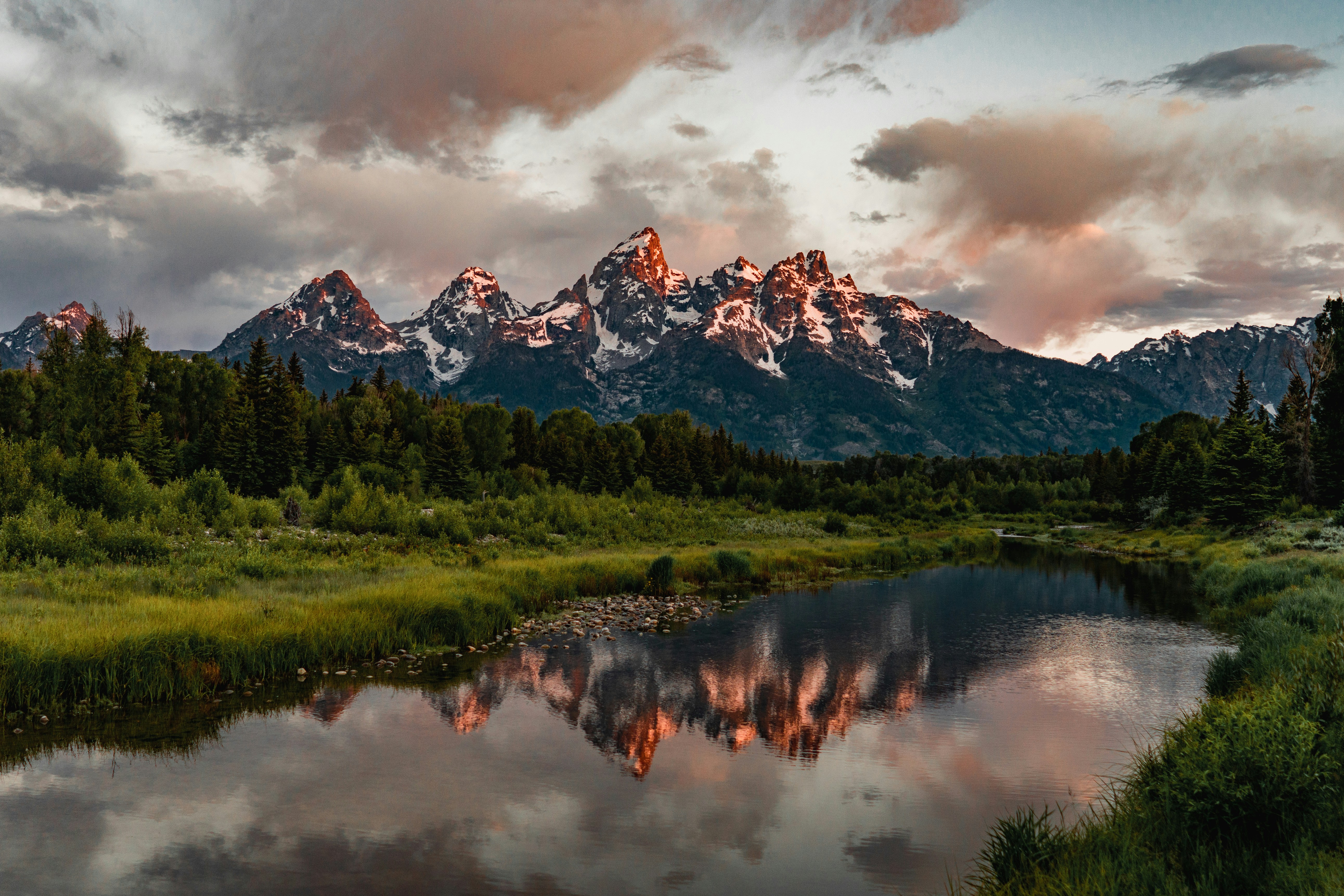
Grand Teton National Park
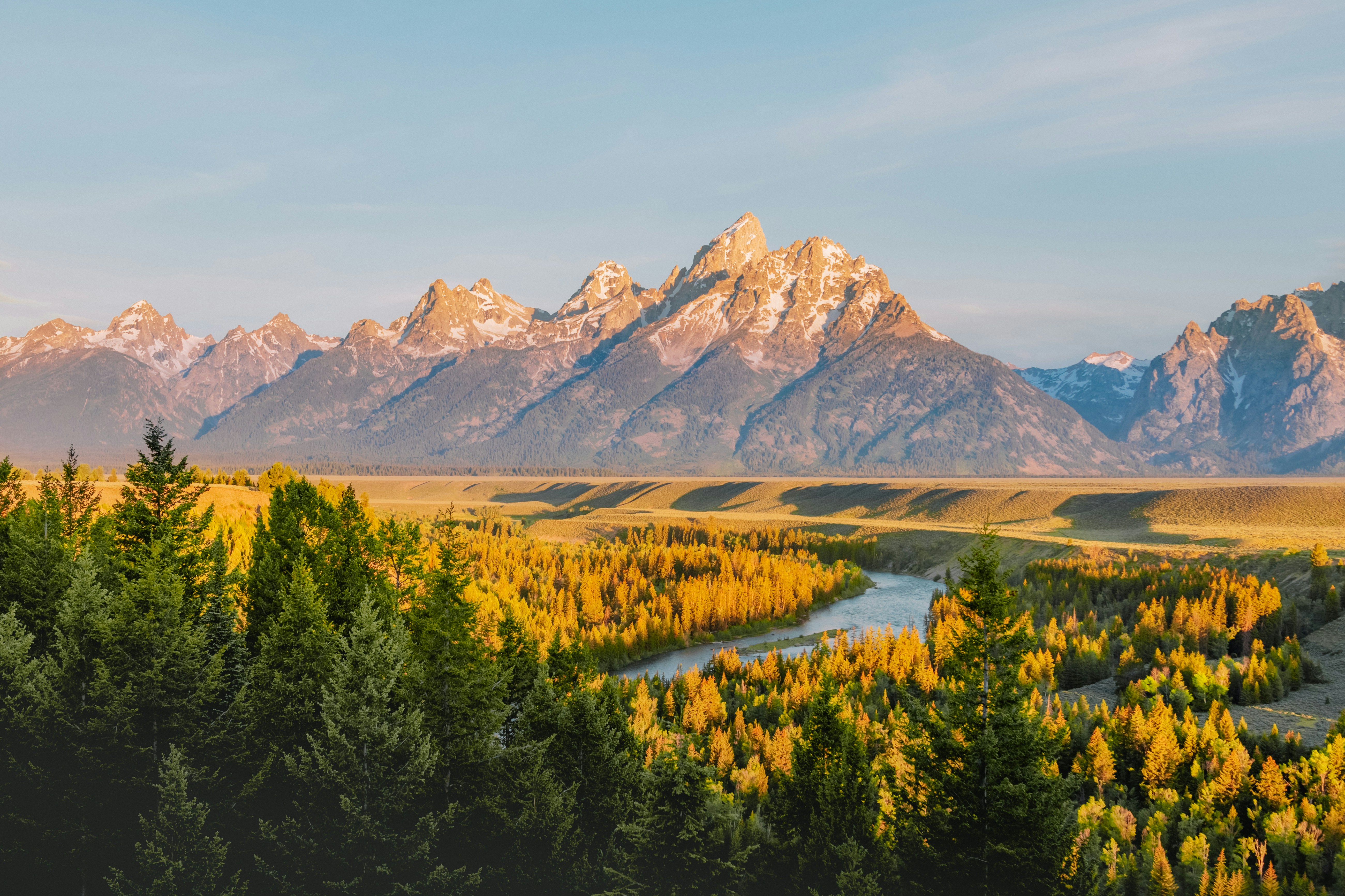
States: Wyoming
Grand Teton National Park, spanning over 310,000 acres in northwestern Wyoming, is a world-renowned destination for its dramatic mountain scenery, diverse ecosystems, and array of recreational activities. The park is bordered by the Snake River to the south and is directly adjacent to the world-famous Yellowstone National Park to the north, making it a major stop for nature lovers and adventure seekers.
Our guided tours to Grand Teton National Park
Yellowstone & Yosemite (Camping/Hotel)
More about Grand Teton National Park
Geography and Natural Features
The park is dominated by the Teton Range, which is part of the Rocky Mountains. The Teton Range was formed relatively recently in geological terms, only about 9 million years ago. The range is characterized by sharp, jagged peaks, deep valleys, and extensive glacial influence. The tallest peak in the range, Grand Teton, rises to 13,775 feet (4,199 meters) and is a popular destination for climbers. The park also features scenic lakes, such as Jackson Lake and Jenny Lake, which were created by glacial activity. Jackson Lake is particularly popular for boating and fishing, while Jenny Lake offers opportunities for hiking and scenic boat tours.
The Snake River flows through the park, providing important habitats for local wildlife and offering opportunities for fishing and rafting. In addition to these geographical features, the park also has several iconic viewpoints, such as Oxbow Bend and Schwabacher’s Landing, that provide breathtaking vistas of the Teton Range, especially during sunrise and sunset.
Wildlife and Ecosystems
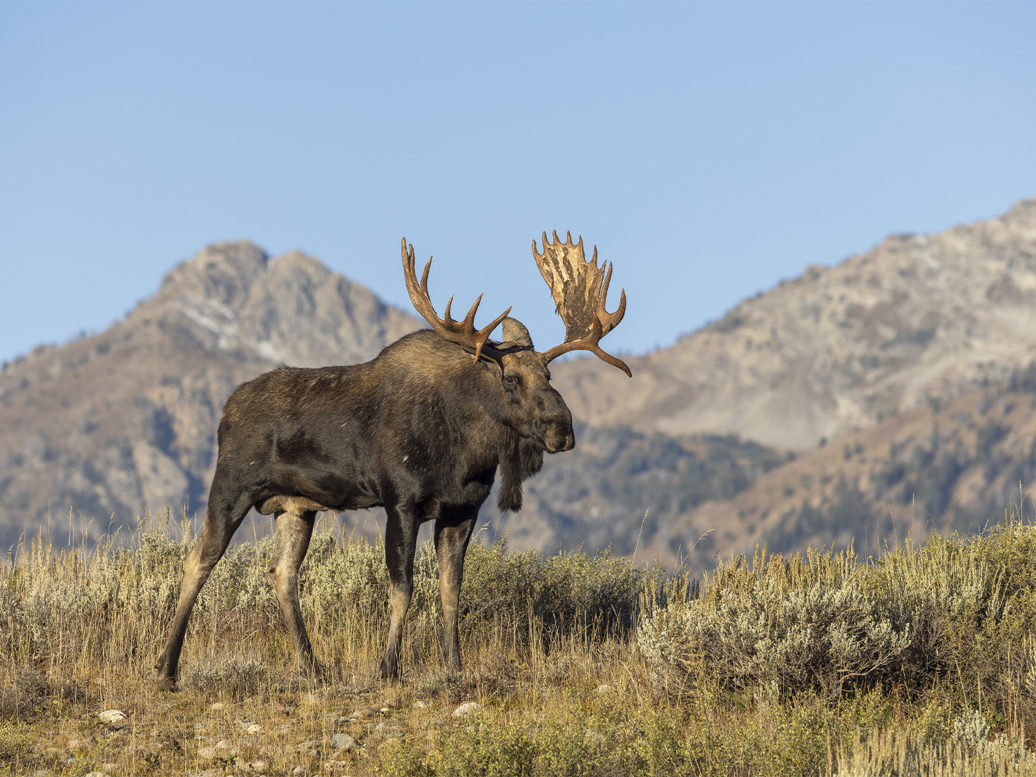
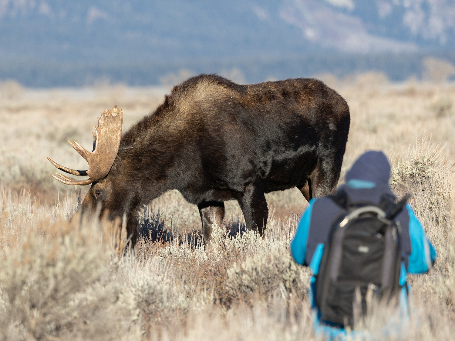
Grand Teton National Park is home to a wide variety of wildlife, thanks to its diverse ecosystems, ranging from wetlands to alpine meadows. Visitors can spot animals such as bison, elk, moose, mule deer, black bears, and grizzly bears. The park also supports a variety of bird species, including bald eagles, ospreys, and sandhill cranes.
In addition to its large mammals and birds, the park’s ecosystems support many smaller species, such as river otters, beavers, and various amphibians. Visitors often encounter these animals along the park’s hiking trails or while boating on its lakes.
Frequently asked questions
When is the best time to visit Grand Teton National Park?
The best time to visit is during the summer months, from late June to early September, when the weather is warmer and most park facilities are open. However, the spring and fall months can offer fewer crowds and unique wildlife viewing opportunities.
What should I bring for a visit to Grand Teton National Park?
Visitors should bring appropriate clothing for changing weather conditions, including layers for cooler temperatures at higher elevations. Sturdy hiking boots, sunscreen, a hat, and plenty of water are also recommended. If camping or hiking in the backcountry, proper gear and navigation tools are essential.
Is Grand Teton National Park accessible for people with disabilities?
Yes, the park has several accessible facilities and trails. For example, there are accessible viewpoints, picnic areas, and boardwalks along some of the lakes and rivers. The visitor centres also offer information on accessible routes and services.
Is Grand Teton National Park accessible for people with disabilities?
Yes, the park has several accessible facilities and trails. For example, there are accessible viewpoints, picnic areas, and boardwalks along some of the lakes and rivers. The visitor centers also offer information on accessible routes and services.
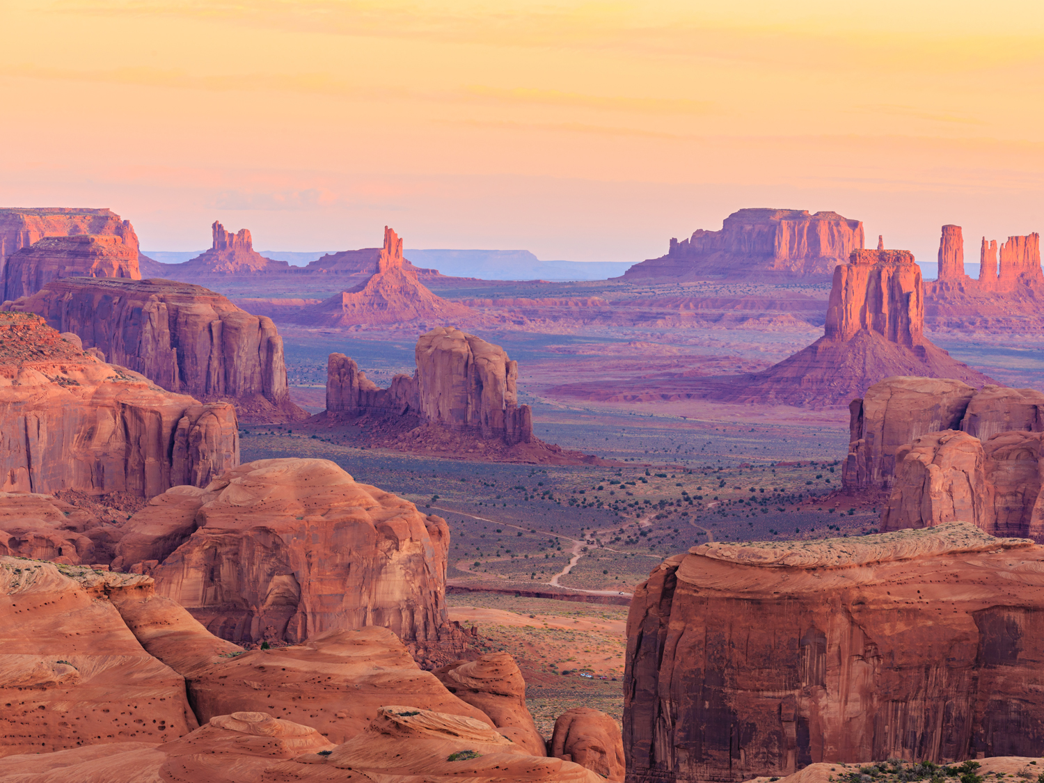
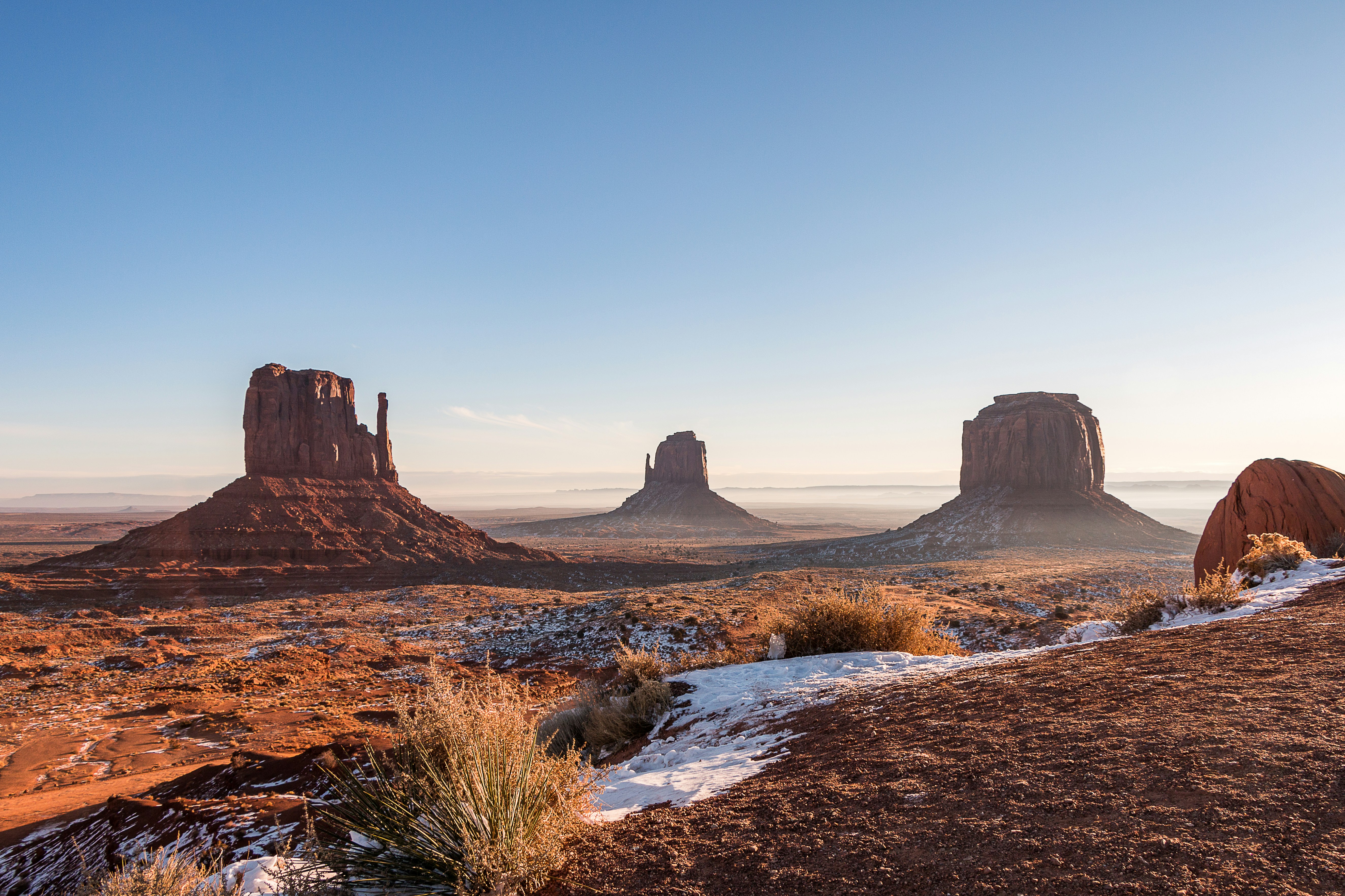
Monument Valley
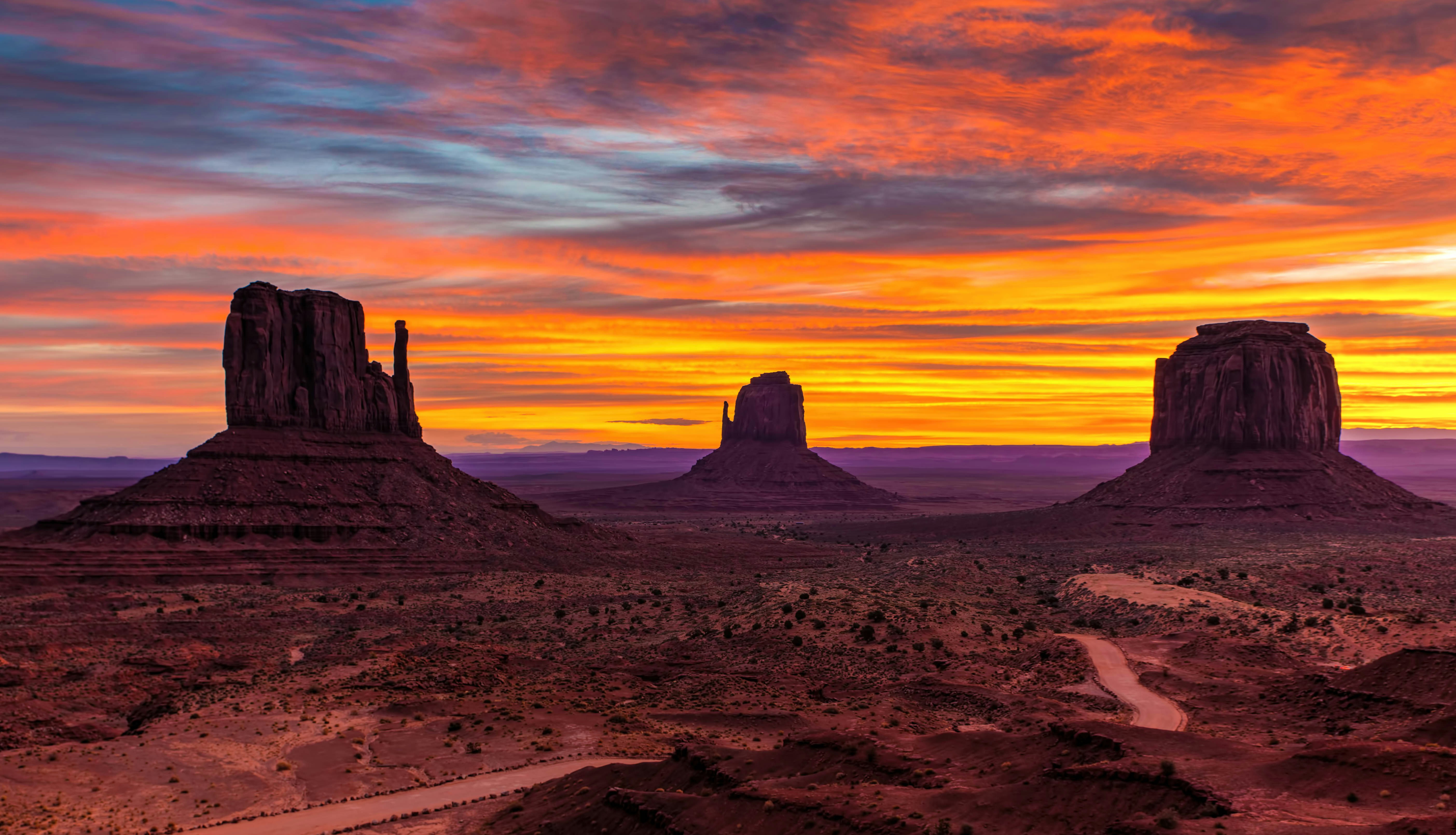
States: Arizona
Monument Valley is one of the most visually striking landscapes in the United States. Situated on the Arizona-Utah border, it spans approximately 91,000 acres of rugged terrain. The valley is part of the larger Navajo Nation, the largest Native American reservation in the country, and the area holds great significance for the Navajo people, both spiritually and historically.
Our guided tours to Monument Valley
Super Southwest USA (Camping)
Southwest National Parks Express (Camping)
More about Monument Valley
Geographic Features
Monument Valley is characterized by its expansive desert vistas, where iconic sandstone formations—often referred to as "monuments"—dominate the landscape. These formations are the result of millions of years of geological processes, including erosion and weathering. The result is a stunning array of natural features such as:
• Buttes: Steep, flat-topped mountains that rise abruptly from the surrounding landscape. Some of the most famous buttes in Monument Valley include The Mitten Buttes (West and East) and Merrick Butte.
• Mesas: Large, isolated flat-topped hills with steep sides, often found throughout the valley.
• Spire-like formations: Tall, narrow rock structures that seem to pierce the sky.
The valley is also home to other geological formations such as arches, rock arches, and natural bridges. These unique features make Monument Valley a photographer’s paradise, especially at sunrise or sunset when the soft light casts long shadows across the formations, creating dramatic effects.
History and Cultural Significance
The Navajo people, or Diné, have lived in the region for centuries, and Monument Valley is an integral part of their heritage. The valley is a sacred place for the Navajo, and many of the formations are named after key figures, animals, or events in their stories. For example, The Three Sisters is a group of three buttes, each representing a part of the Navajo creation story.
Monument Valley became widely known through Hollywood films, particularly Westerns. Director John Ford famously used it as a backdrop for several of his films, starting with Stagecoach (1939), which helped solidify its place as a cinematic symbol of the American West. Since then, the valley has appeared in countless films, TV shows, and commercials, cementing its iconic status.
Visitor Experience
Today, Monument Valley is managed by the Navajo Nation, and visitors can explore it through the Monument Valley Navajo Tribal Park. The park offers guided tours led by Navajo guides, who provide in-depth knowledge of the area’s geology, history, and cultural significance. Visitors can take scenic drives, including the popular Valley Drive, which takes them past some of the most famous formations.
There are also opportunities for hiking, photography, and stargazing. The clear desert skies offer breathtaking views of the stars, and the quiet solitude of the valley makes it a peaceful retreat for those looking to immerse themselves in nature.
Frequently asked questions
What is the best time to visit Monument Valley?
The best times to visit are during the spring and fall when the weather is mild, with cooler temperatures and clearer skies. Summer can be extremely hot, and winter can bring cold temperatures and snow, although the landscape is even more striking during these seasons.
Can I hike in Monument Valley?
There are limited hiking opportunities in Monument Valley, but there are several designated trails, such as the Wildcat Trail, which is a 3.2-mile loop that provides excellent views of the West Mitten Butte. Guided hikes are also available, where you can learn more about the land and the Navajo culture.
Is Monument Valley open year-round?
Yes, Monument Valley is open year-round, though weather conditions can vary by season. The park is usually busiest from March to October, with fewer crowds in winter months. However, some areas may be closed during extreme weather conditions.
What should I bring when visiting?
Be sure to bring plenty of water, especially in the hotter months. Sunscreen, a hat, sturdy hiking shoes, and a camera are also highly recommended. Temperatures can fluctuate widely, so it’s a good idea to wear layers.